
The Mill
Background: generated illustration, not a photograph of this location.
Review The Mill's Minister Brook identity, current parking questions, historical monitoring limits and dam scenery without unverified jumping or access promises.
Location
Map & Directions
A closer look
Photos of The Mill
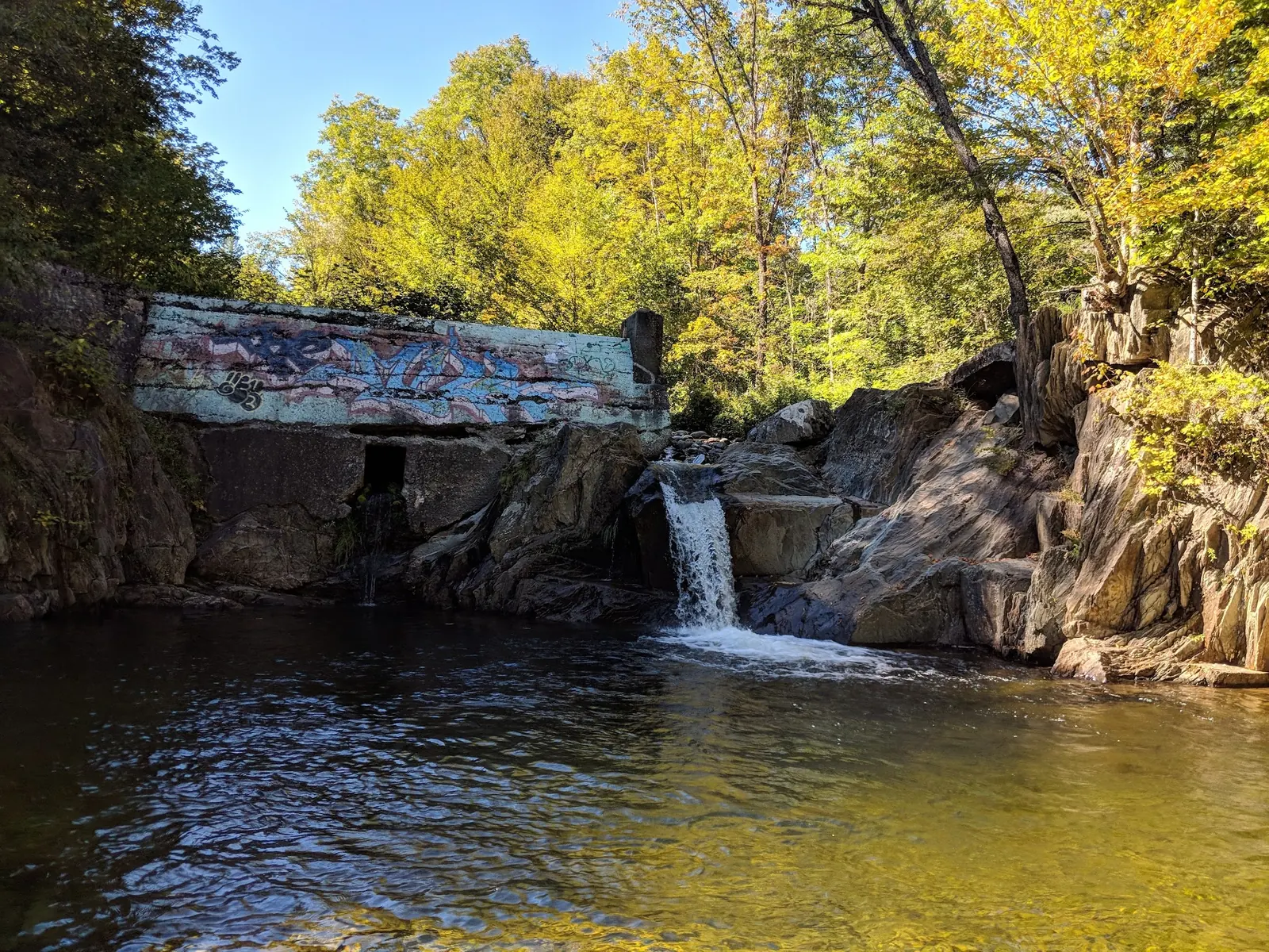
Photos show past visits, not current water levels or swimming conditions. Select a photo to view it larger.
Sources & checks
This is a desk-researched listing. A record update or map check does not confirm current swimming permission or water conditions.
- Swimming rules
- Official sources checked . Swimming permission remains unconfirmed.
- Access location not verified
- The recorded location has no completed source check. Confirm the entrance, legal access, and parking before travelling.
- Record updated
- · This is a data update, not a field visit.
Found an error? Send a correction with the location and a source. How we research listings.
The Mill on Minister Brook: identity versus access
The government Water Quality Portal identifies a Vermont DEC station described as Minister Brook Dam Swimming Hole. Its location agrees closely with the saved The Mill collection on Minister Brook Road in Worcester. The former East Calais town point was not the hole and has been removed.
Do not confuse a location match with permission
The station and historic dam imagery support the feature's identity. They do not establish public ownership, a legal parking space, an entrance or current swimming authorization. The archived directions themselves mention a No Parking stretch. A restriction is not a trailhead marker or permission to park just beyond it.
Check the current visit questions first
Parking and the brook approach
The town publishes parking and other ordinances. Consult current notices and ask about this exact road and entrance before leaving. No measured current approach or accessible route was established. Do not assume the informal bank descent remains permitted.
Historical tests are not current water guidance
The station profile displays monitoring records from 2010 and describes interpolated coordinates without accuracy metadata. These are not today's recreational-water clearance. Water color and photos cannot establish bacteria levels, safe depth or current. Earlier jumping-ledges, predictable summer conditions and unsupervised-entry recommendations have been withdrawn.
Separate swimming options from this site
The town recreation page identifies Lake Elmore and Wrightsville Reservoir as swimming options. Those are different destinations with their own managers, fees and conditions, not proof that The Mill is authorized. Current Mill toilets, camping, lifeguards and entry fees have not been verified.
Use the gallery as historical scenery
The selected image shows dam remnants and a brook pool. It is not a jumping recommendation, a measured-depth diagram or a current access photo. Do not climb on deteriorated structures or treat the dam as a recreational platform.
Getting There
Archived directions identify Minister Brook Road off Route 12 near Worcester and a No Parking stretch. This is historical feature context, not a current entrance or parking instruction. Check the town's current ordinances and ask about legal access before travel. Do not descend an informal embankment without permission.
Quick Navigation
Access Notes
WQP identifies Minister Brook Dam Swimming Hole and saved imagery shows dam remnants. These support site identity, not property rights, parking authorization or a maintained path.
Plan Your Visit
Parking & Access
Confirm the entrance, parking arrangements, and legal access with the land manager. A map pin does not establish a public right of access. Follow posted routes and never block gates or driveways.
Regulations & Fees
Current swimming permission has not been independently confirmed for this listing. Check official rules, fees, hours, and closures before visiting. Public park access does not necessarily include permission to swim. Respect private property and posted restrictions.
Seasonality & Flow
Water conditions can change quickly. This listing does not provide a current safety or water-quality assessment. Check official alerts and avoid entering water when conditions or permission are uncertain.
Frequently Asked Questions About The Mill
Is this The Mill on Minister Brook?
The government station description and closely matching Google collection support that identity. Current public access is a separate unresolved question.
Where can I park?
No legal parking space is verified. The archive mentions a No Parking area; check current town ordinances and posted restrictions rather than parking by inference.
Can I swim or jump from the dam?
Current bathing permission and safe water conditions are not established. Dam remnants and drops should not be treated as jumping platforms.
Does the station prove current water quality?
No. The profile displays data from 2010, not a current bathing-water clearance.
Are facilities or camping available?
No current site-specific services or camping authorization have been verified. Do not assume an overnight stay or supervised swimming.
What other swimming places does the town identify?
Its recreation page lists Lake Elmore and Wrightsville Reservoir. They are separate destinations whose managers' current rules and conditions must be checked.
Highlights
Unique Features
Location & Area Map
Safety Information
Important Safety Tips
- Dam remnants, drops and submerged structures are hazards, not jumping platforms
- No safe depth, current, supervised bathing or current water-quality clearance established
- The government station's displayed data are from 2010, not a present swim advisory
Cultural & Historical Context
Historical Background
Government monitoring metadata names a Minister Brook dam swimming hole. The review does not invent a mill construction history or claim the structure is maintained.
Photography Guide
Photo Opportunities
Historical dam and brook scenery only from permitted viewpoints. Gallery does not verify safe depth, a bank route or current water-entry permission.
Conservation & Ethics
Protect This Place
Respect property boundaries, stay on permitted paths and pack out waste. Do not create bank routes, disturb wildlife or assume pet access.
Explore More Nearby Swimming Guides
More Vermont swimming holes
Browse every listed natural swimming spot in Vermont.
Brook swimming holes
Find similar brook destinations across the directory.
Hidden gems in Vermont
See under-the-radar places and local favorites in the same state.
Family-friendly spots in Vermont
Compare easier-access destinations and safer planning options.
Check water quality before swimming
Use this safety guide before entering any natural water.
You Might Also Like
At a Glance
Safety & Access Notice
This information is for general planning only and may be incomplete, outdated, or inaccurate. Access rules, closures, water levels, currents, hazards, and legal restrictions can change at any time. Always verify current rules with the land manager or official source before visiting.
You are responsible for your own safety and for following all posted signs, laws, and local regulations. Read the full disclaimer.
Camping Information
No overnight permission verified; plan accommodation separately.
Loading weather data…
Safety & Access Notice
This information is for general planning only and may be incomplete, outdated, or inaccurate. Access rules, closures, water levels, currents, hazards, and legal restrictions can change at any time. Always verify current rules with the land manager or official source before visiting.
- Do not swim where swimming is prohibited, unsafe, or not clearly allowed.
- Follow posted signs, local regulations, closures, and private-property boundaries.
- Assess conditions on site. Water flow, depth, temperature, and underwater hazards change quickly.
- Never jump or dive without personally confirming depth and underwater obstacles.
- Swim with a buddy and consider flotation for weak or non-swimmers.
- Pack out all trash; respect wildlife and fragile environments.
You are responsible for your own safety and for following all posted signs, laws, and local regulations. Read the full disclaimer.
Joshua Havens created Hidden Swimming Holes to make it easier for people to find — and safely visit — natural freshwater swimming destinations across the United States. He researches access conditions, water quality resources, and land management rules so you don't have to start from scratch. He holds a strong belief that good outdoor recreation information should be accurate, honest about its limitations, and freely available.
Explore More Swimming Holes
Discover other amazing natural swimming destinations across America