Right spot. Right season.

Seasonal & Skill-Level Planner

Use recorded seasonal and approach descriptions to organize your research. These groups are not verified operating schedules, swimming-skill ratings or current-condition reports.

7
Season-specific spotlights
10
Approach-description groups
6
States leading the list
Planning intelligence
  • Use the difficulty descriptions to match your group. If a spot mentions uneven terrain or rope assists, plan for sturdy footwear and gloves.
  • Recorded seasonal descriptions need confirmation with the operator; they do not establish current water levels, crowds or access.
  • Always cross-reference weather forecasts. Flash floods, snowmelt, or wildfire smoke can quickly change swimming conditions.
  • Pack layers even for summer outings. Mountain storms and canyon shade can drop temperatures faster than you expect.
Top planner states
  • Florida 26 standout spots
  • California 24 standout spots
  • Oregon 22 standout spots
  • West Virginia 22 standout spots
  • Vermont 21 standout spots
  • Arkansas 19 standout spots
Forecast snapshot

Use local weather services or our spot-level updates to confirm flow, water temperature, and wildfire conditions. Conditions can change faster than guidebooks.

Summer Notes in the Directory

These records explicitly mention summer in their visit notes. Read the complete note and check current opening dates and conditions; a season label does not predict crowds, flow or safe water.

Summer noted View details →

Berkeley Springs S. P.

West Virginia

Generated illustration of a natural swimming setting; not a photograph of this location Illustration
Generated illustration, not a photograph of this location. Listing details

This downtown West Virginia park offers three different experiences: a seasonal outdoor swimming pool, public springs for wading, and bookable bathhouse services. Do not confuse the historic stone basins and spring…

Recorded seasonal notes

For the outdoor pool, check its published summer season and current operating days. Bathhouses and public springs have separate schedules.

Trip highlights
  • Seasonal spring-fed outdoor swimming pool
  • Year-round public springs for wading
  • Separate bathhouse services and reservations
Why we love it
Historic spring features in a downtown parkOutdoor pool distinct from the public spring channels
Make it a combo
  • [object Object]
  • [object Object]
Best season For the outdoor pool, check its published summer season and current operating days. Bathhouses and public springs have…
Access insights Easy access, located in downtown Berkeley Springs. Camping in nearby Sleepy Creek Hunting and Fishing Area requires navigating rough roads.
Cost Public spring access is free. Confirm separate pool and bathhouse charges with the park.
Facilities Choose the facility before booking. The Main Bathhouse offers Roman or whirlpool mineral baths, massage packages and…
Summer noted View details →

Blackwater River S. P.

Florida

White sandbanks beside the Blackwater River with pine forest beyond Location photo
Past-visit location photo, not verified water entry or current conditions. Gallery and sources

River beaches and forest make this a place to plan a day outdoors near Milton. Check current park notices before leaving. Use the official address: 7720 Deaton Bridge Road, Milton, FL 32564. The park warns of GPS…

Recorded seasonal notes

Check river levels, weather and park notices. Summer weekends can bring parking pressure; no season guarantees suitable swimming conditions.

Trip highlights
  • River beaches and sandbanks
  • Boardwalk near picnic facilities
  • Separate state-park campground
Why we love it
Forest-lined river beachesBoardwalk near picnic facilities
Best season Check river levels, weather and park notices. Summer weekends can bring parking pressure; no season guarantees suitable…
Access insights Boardwalk approach near the pavilions; beach sand and final water entry require individual assessment.
Cost $4 per vehicle; exact change for the honor box. Confirm current fees before travelling
Facilities Restrooms, picnic pavilions and an outdoor shower. A boardwalk connects the pavilion area to the river beach. Confirm…
Summer noted View details →

Colorado Bend S. P.

Texas

Colorado Bend State Park name carved into a stone sign beside grass and trees Location photo
Past-visit location photo, not verified water entry or current conditions. Gallery and sources

Swimming is allowed at Spicewood Springs and in the Colorado River. No lifeguards are provided. Do not swim or wade in the Gorman Falls area, Gorman Creek or Gorman Spring. Follow current park closures and posted…

Recorded seasonal notes

Check water levels, road conditions and park alerts before choosing a date. Spring and summer are busy; reserve entry ahead.

Trip highlights
  • Spicewood Springs swimming pools
  • Colorado River access
  • Gorman Falls sightseeing, not swimming
Why we love it
Spring-fed pools and river access are separate swimming optionsGorman Falls has protected formations and no swimming
Make it a combo
  • [object Object]
Best season Check water levels, road conditions and park alerts before choosing a date. Spring and summer are busy; reserve entry a…
Access insights The park describes a short, flat approach to the first Spicewood Springs pool. Continuing farther is a different outing; confirm your route…
Cost $5 daily adult entry; children 12 and under free. Camping costs extra; confirm current rates
Facilities Facilities depend on the area. Walk-in campsites list nearby water and restrooms; backcountry River and Windmill…
Summer noted View details →

Golden Lake Park Beach

Minnesota

Generated illustration of a natural swimming setting; not a photograph of this location Illustration
Generated illustration, not a photograph of this location. Listing details

Golden Lake Park combines a swimming beach with picnic areas, playgrounds and a fishing pier. Minnesota DNR lists no park entrance fee and confirms restrooms and parking. This listing is for Circle Pines, Minnesota,…

Recorded seasonal notes

During the local summer swimming season, after checking current beach notices.

Trip highlights
  • No park entrance fee listed by Minnesota DNR
  • Beach and picnic facilities
  • Restrooms and parking
Why we love it
Swimming beach within a city park
Best season During the local summer swimming season, after checking current beach notices.
Access insights Beach access; check individual mobility requirements with the park.
Cost Listed as no fee; confirm current charges.
Facilities Restrooms, parking, picnic grills, playgrounds, fishing pier and rentable pavilions.

Winter and Year-Round Visit Notes

These records contain winter or year-round visit notes. That wording does not establish warm water, an open access road or year-round swimming. Check the exact operator schedule and route notices.

Winter or year-round noted View details →

Granite Hot Springs

Wyoming

Generated illustration of a natural swimming setting; not a photograph of this location Illustration
Generated illustration, not a photograph of this location. Listing details

Granite Hot Springs is a developed, spring-fed concrete soaking pool in Bridger-Teton National Forest. Plan around the access season rather than treating it as a roadside swimming stop. The pool and the nearby creek…

Recorded seasonal notes

Choose an operating summer or winter season and confirm opening dates directly. Road access and pool operation can differ.

Trip highlights
  • Developed spring-fed concrete pool
  • Summer road access when conditions allow
  • Winter snow travel required
Why we love it
Forest setting beside Granite CreekDeveloped soaking pool rather than a natural creek swimming hole
Make it a combo
  • [object Object]
  • [object Object]
Best season Choose an operating summer or winter season and confirm opening dates directly. Road access and pool operation can diff…
Access insights Season-dependent: unpaved road approach in summer; winter travel requires suitable transport, preparation and a return plan.
Cost Admission charged; call 307-690-6323 to confirm current prices and payment methods.
Facilities The tourism board documents a dressing room. Ask the operator about toilets, step-free access and other facilities…
Winter or year-round noted View details →

Hot Springs S. P.

Wyoming

Generated illustration of a natural swimming setting; not a photograph of this location Illustration
Generated illustration, not a photograph of this location. Listing details

For a free mineral-water soak in Thermopolis, look for the State Bath House within Hot Springs State Park. This is a managed bathing facility, not an invitation to enter the spring source, mineral terraces or Bighorn…

Recorded seasonal notes

Plan around confirmed Bath House hours and current construction status. Holiday and winter schedules should be checked by phone.

Trip highlights
  • Free State Bath House soaking
  • Outdoor-pool reopening needs confirmation
  • Mineral terraces viewed from designated paths
Why we love it
Managed mineral-water Bath HouseMineral terraces beside the Bighorn River
Make it a combo
  • [object Object]
  • [object Object]
Best season Plan around confirmed Bath House hours and current construction status. Holiday and winter schedules should be checked…
Access insights Developed park access; confirm the pool entrance, construction detours and any accessibility assistance needed.
Cost State Bath House soaking is free; other pool businesses have separate admission arrangements.
Facilities The State Bath House is separate from other pool operations. Park restrooms, trails and picnic areas are listed by…
Winter or year-round noted View details →

Saratoga

Wyoming

Generated illustration of a natural swimming setting; not a photograph of this location Illustration
Generated illustration, not a photograph of this location. Listing details

This listing covers Saratoga's public Hobo Pool, not Saratoga Hot Springs Resort. The town-run soaking area sits beside the North Platte River. The Carbon County Visitors Council describes it as free, with a published…

Recorded seasonal notes

The visitors council publishes year-round, 24-hour access. Recheck the town facility notice and travel conditions before leaving.

Trip highlights
  • Free public Hobo Pool
  • Published 24-hour schedule, subject to local notices
  • Restrooms and changing facilities
Why we love it
Public geothermal soaking beside the North Platte RiverTown-listed Not So Hot Pool
Make it a combo
  • [object Object]
  • [object Object]
Best season The visitors council publishes year-round, 24-hour access. Recheck the town facility notice and travel conditions befor…
Access insights In-town developed soaking area; confirm parking and any accessibility needs locally.
Cost Free public Hobo Pool; commercial resort admission is separate.
Facilities The visitors council documents restrooms and changing facilities; the town identifies a picnic area. Ask about any…

Weather changes: reassess the trip

This directory does not identify rain-safe swimming locations. A mention of rain or monsoon season in a listing may be a warning, not a recommendation. Check official closures and local forecasts, and choose a dry-land alternative when conditions are uncertain.

Listings Described as Easy to Reach

These records mention easy or accessible approaches. That wording does not verify accessible water entry, gentle currents, supervision or suitability for children. Confirm the full route and swimming rules before visiting.

Check approach details View details →

Berkeley Springs S. P.

West Virginia

Generated illustration of a natural swimming setting; not a photograph of this location Illustration
Generated illustration, not a photograph of this location. Listing details

This downtown West Virginia park offers three different experiences: a seasonal outdoor swimming pool, public springs for wading, and bookable bathhouse services. Do not confuse the historic stone basins and spring…

Recorded seasonal notes

For the outdoor pool, check its published summer season and current operating days. Bathhouses and public springs have separate schedules.

Trip highlights
  • Seasonal spring-fed outdoor swimming pool
  • Year-round public springs for wading
  • Separate bathhouse services and reservations
Why we love it
Historic spring features in a downtown parkOutdoor pool distinct from the public spring channels
Make it a combo
  • [object Object]
  • [object Object]
Best season For the outdoor pool, check its published summer season and current operating days. Bathhouses and public springs have…
Access insights Easy access, located in downtown Berkeley Springs. Camping in nearby Sleepy Creek Hunting and Fishing Area requires navigating rough roads.
Cost Public spring access is free. Confirm separate pool and bathhouse charges with the park.
Facilities Choose the facility before booking. The Main Bathhouse offers Roman or whirlpool mineral baths, massage packages and…
Check approach details View details →

Fairy Stone S. P.

Virginia

Generated illustration of a natural swimming setting; not a photograph of this location Illustration
Generated illustration, not a photograph of this location. Listing details

Fairy Stone Lake has a designated swimming beach in Patrick County, Virginia. It is not an unofficial roadside swimming hole, and it is not the same swimming destination as neighboring Philpott Reservoir. Plan your…

Recorded seasonal notes

Choose a visit around current weather, beach notices and the services you need, not a guaranteed water temperature.

Trip highlights
  • Designated lake swimming beach
  • Camping and cabin options
  • Fairy stone programs
Why we love it
Fairy stones, unique cross-shaped crystalsPart of Virginia’s original state parks
Make it a combo
  • [object Object]
  • [object Object]
Best season Choose a visit around current weather, beach notices and the services you need, not a guaranteed water temperature.
Access insights Beach approach and accessible water-entry details should be confirmed with park staff.
Cost Parking fee applies; consult official fee schedule
Facilities Beach restrooms are listed. Confirm current changing facilities, accessible beach entry and seasonal services with the…
Check approach details View details →

Margaret Lindley Park

Massachusetts

Margaret Lindley Park pond and sandy shore surrounded by woodland Location photo
Past-visit location photo, not verified water entry or current conditions. Gallery and sources

Margaret Lindley Park is operated by Williamstown's Conservation Commission and the town. Its park page identifies a pond with an artificial beach fed by Hemlock Brook. Swimming runs Memorial Day through Labor Day,…

Recorded seasonal notes

For swimming, choose a date within Memorial Day-Labor Day and check current test notices. For a trail or picnic visit, follow dawn-to-dusk guidance and local restrictions.

Trip highlights
  • Town-operated seasonal swimming pond
  • Picnic lawn, tables and grills
  • Year-round woodland trails beside Hemlock Brook
Why we love it
Hemlock Brook feeds the beach pond; woodland trails lead toward Harmon Pond wetland
Best season For swimming, choose a date within Memorial Day-Labor Day and check current test notices. For a trail or picnic visit,…
Access insights Trail and beach routes have different surfaces and requirements. Confirm the route and mobility needs rather than inferring an accessible a…
Cost A current admission charge is not published on the reviewed town park pages. Confirm any group-use or reservation requirements with the town.
Facilities The town says a summer Park Ranger works Tuesday through Saturday. Ranger presence is not confirmation of lifeguard…
Check approach details View details →

Ocqueoc Falls

Michigan

Wide view of Ocqueoc Falls spilling over low rock ledges beneath woodland Location photo
Past-visit location photo, not verified water entry or current conditions. Gallery and sources

This is a managed destination with documented accessibility work, not an unofficial roadside stop. If you want a longer outing beyond the developed falls approach, Pure Michigan's pathway description lists four loops…

Recorded seasonal notes

No exact falls opening timetable verified. Ask DNR about closures and seasonal service.

Trip highlights
  • Official accessible-visit information
  • Vehicle-pass planning
  • Five reviewed seasonal and destination photographs
Best season No exact falls opening timetable verified. Ask DNR about closures and seasonal service.
Access insights Accessible developed approach described by DNR; natural rock and water entry require a separate assessment for your needs.
Cost Recreation Passport required for motor-vehicle access; camping costs extra. Check current prices, not the old free-parking claim.
Facilities Campground page lists vault toilets and hand-pump water; falls-side availability unverified. Confirm seasonal service…

Listings Described as Moderate

Moderate is a description from the listing, not a swimming-skill rating. Verify the terrain, distance and current access with the land manager.

Moderate approach noted View details →

Bass Lake

California

Bass Lake near Bolinas surrounded by wooded slopes and dense shoreline vegetation Location photo
Past-visit location photo, not verified water entry or current conditions. Gallery and sources

This is the small wilderness lake in Point Reyes National Seashore, not the larger Bass Lake near Yosemite. Plan a hike from Palomarin Trailhead, not a drive to the shoreline. NPS describes swimming here as unofficial,…

Recorded seasonal notes

Check weather and park advisories; arrive early for parking. No warm-water guarantee.

Trip highlights
  • Wooded wilderness lake near Bolinas
  • Coast Trail approach from Palomarin
  • Unofficial swimming without lifeguards
Why we love it
Wooded lake settingCoastal hiking approach
Make it a combo
  • [object Object]
  • [object Object]
Best season Check weather and park advisories; arrive early for parking. No warm-water guarantee.
Access insights Moderate hike, approximately six miles round trip including the shore approach.
Cost Listed as no fee; confirm current charges.
Facilities Use trailhead toilets before hiking. Bring your own drinking water and pack out waste.
Moderate approach noted View details →

White Rock Falls

Virginia

Water cascading between large mossy boulders into a rock-lined pool at White Rock Falls Location photo
Past-visit location photo, not verified water entry or current conditions. Gallery and sources

The NPS Virginia trail table distinguishes the moderate 0.9-mile White Rock Falls trail at milepost 20 from the 2.9-mile connection at milepost 18.5. Its page is dated November 1, 2024, so use these as route…

Recorded seasonal notes

Check Parkway access, weather and stream conditions before visiting. No season guarantees safe swimming.

Trip highlights
  • Waterfall hike from The Slacks Overlook
  • Roughly two-mile out-and-back route
  • Natural pool with variable conditions
Why we love it
Rock-walled waterfall setting near Parkway milepost 20
Best season Check Parkway access, weather and stream conditions before visiting. No season guarantees safe swimming.
Access insights Moderate hike with descent and return climb; allow roughly two miles out and back from The Slacks.
Cost Parkway road guidance does not establish every activity or nearby campground charge. No falls-specific admission fee verified in this review.
Facilities Bring drinking water and supplies for the hike. Sherando amenities belong to a separate recreation area.

Listings With Demanding Approaches

These records describe demanding terrain. That does not rate swimming difficulty or establish a route suitable for your group. Read the full approach notes and check restrictions before choosing the trip.

Demanding approach noted View details →

Calf Creek Swimming And Recreation Area

Utah
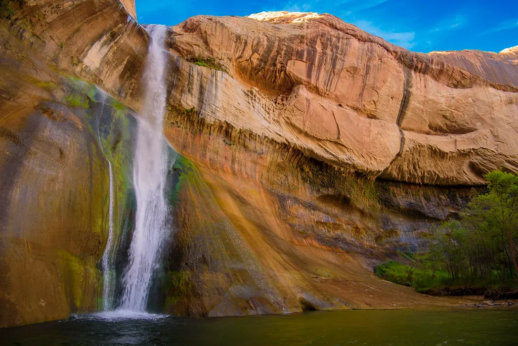
Lower Calf Creek Falls descending beside tall sandstone walls into its natural pool Location photo
Past-visit location photo, not verified water entry or current conditions. Gallery and sources

Calf Creek Recreation Area lies along UT-12 between Escalante and Boulder. Do not confuse creek access near the developed recreation area with the waterfall farther up the canyon. Use the trailhead restroom before…

Recorded seasonal notes

Choose weather suitable for the full return hike. Summer heat and sandy trail sections require extra planning; consult current BLM notices before setting out.

Trip highlights
  • Campground/day-use creek access
  • Six-mile round-trip Lower Falls hike
  • BLM rockfall warning at the waterfall
Why we love it
Creek-side developed recreation area126-foot Lower Calf Creek Falls reached on foot
Make it a combo
  • [object Object]
  • [object Object]
Best season Choose weather suitable for the full return hike. Summer heat and sandy trail sections require extra planning; consult…
Access insights Campground water play is separate from the moderately difficult, sandy six-mile round-trip Lower Falls hike.
Cost BLM lists $5 per vehicle for day use; confirm current fees and pass eligibility before visiting.
Facilities Toilets and picnic tables are at the developed recreation area. Do not assume those amenities are available at the…
Demanding approach noted View details →

Cummins Falls

Tennessee

Generated illustration of a natural swimming setting; not a photograph of this location Illustration
Generated illustration, not a photograph of this location. Listing details

The 75-foot waterfall on Blackburn Fork can be viewed from above or approached through the river gorge. These are different outings: the overlook avoids the river route, while reaching the waterfall base involves…

Recorded seasonal notes

Check gorge status, permit availability and seasonal park hours before traveling. Leave enough time for the return hike.

Trip highlights
  • 75-foot waterfall
  • Separate overlook and gorge routes
  • Permit-controlled access to the waterfall base
Why we love it
Blackburn Fork river gorgeWheelchair-friendly overlook with approach arrangements
Make it a combo
  • [object Object]
  • [object Object]
Best season Check gorge status, permit availability and seasonal park hours before traveling. Leave enough time for the return hike.
Access insights Strenuous gorge route with river crossings and slippery rocks; separate overlook options.
Cost Paid Gorge Access Permit required for gorge entry; check current pricing. Other trails do not require this permit.
Facilities The visitor center has a wheelchair-friendly restroom, an accessible outdoor water fountain and a gift shop. Picnic…
Demanding approach noted View details →

Deckers Creek Trail

West Virginia

Generated illustration of a natural swimming setting; not a photograph of this location Illustration
Generated illustration, not a photograph of this location. Listing details

The Mon River Trails Conservancy describes Deckers Creek as a 19.5-mile rail-trail from Morgantown. That corridor is not a single swimming destination. Choose your trailhead and intended outing before departure; the…

Recorded seasonal notes

Check current access, flow and dated water-quality results rather than relying on a swimming season.

Trip highlights
  • Rail-trail scenery
  • Site-specific gorge water-quality information
  • Informal gorge access
Why we love it
Creek corridor near Morgantown and MasontownLocal watershed monitoring
Best season Check current access, flow and dated water-quality results rather than relying on a swimming season.
Access insights Trail route varies; documented gorge access is steep and rocky.
Cost Gorge source describes free gravel parking; check current signs.
Facilities Confirm seasonal restroom availability at the chosen trailhead. Bring water; facilities at trailheads and Lions Club…
Demanding approach noted View details →

Goldstrike Canyon Hot Springs And Colorado River Spots

Nevada

Generated illustration of a natural swimming setting; not a photograph of this location Illustration
Generated illustration, not a photograph of this location. Listing details

Gold Strike Canyon near Boulder City leads through dry falls to natural springs and the Colorado River. The NPS trail-information block checked October 14, 2026 lists 5.3 miles round trip and 1,200 feet of elevation…

Recorded seasonal notes

Check the named destination, current notices and weather before choosing a date.

Best season Check the named destination, current notices and weather before choosing a date.
Access insights NPS very strenuous Grade 2 canyoneering route; current block lists 5.3-mile round trip and 1,200-foot elevation change.
Cost NPS identifies free parking but a park fee area; keep valid pass/admission proof with vehicle and confirm current rates.
Facilities Carry drinking water and pack-out supplies; visitor-installed ropes are not maintained amenities.

More Planner Picks

Compare these additional records using their individual access, seasonal and facility notes. Inclusion does not establish an easy approach or current swimming conditions.

Planner pick View details →

Agua Caliente Park

California

Generated illustration of a natural swimming setting; not a photograph of this location Illustration
Generated illustration, not a photograph of this location. Listing details

San Diego County describes two outdoor pools and an indoor spa at Agua Caliente. Choose the pool that fits your group and check its current schedule. Managed mineral water is not a promise of medical benefit or…

Recorded seasonal notes

Select a currently open date and eligible pool slot, not a generic desert early-morning summer plan.

Trip highlights
  • Three developed pools distinguished
  • Separate parking and non-camper pool charges
  • Seasonal closure and age/evening eligibility
Best season Select a currently open date and eligible pool slot, not a generic desert early-morning summer plan.
Access insights Developed park does not establish universal accessible pool entry; confirm the route/equipment needed with staff.
Cost Posted $5 day-use parking plus $7 pool entry per non-camper; confirm current terms.
Facilities Check pool-specific access and staff guidance. County offers tent/full/partial hookup sites and cabins; no universal…
Planner pick View details →

Alum Creek Reservoir

Ohio

Wide sandy swimming beach beside Alum Creek Reservoir with a paved path along the grass Location photo
Past-visit location photo, not verified water entry or current conditions. Gallery and sources

Alum Creek Reservoir is not an unrestricted shoreline swimming destination. For a shore-based visit, use Alum Creek State Park's public swimming beach. Previous directions on this page pointed to the Howard Road boat…

Recorded seasonal notes

Visit during daylight hours after checking current beach conditions and seasonal facilities.

Trip highlights
  • Designated public swimming beach
  • Changing area, outdoor showers and restrooms
  • Separate campground for overnight stays
Why we love it
Reservoir swimming in designated areas, not unrestricted shoreline access
Best season Visit during daylight hours after checking current beach conditions and seasonal facilities.
Access insights Use the public beach access; confirm the approach and any accessibility requirements with park staff.
Cost Confirm current day-use arrangements with the park; camping and reservations are separate
Facilities The public beach has restrooms, a changing area and outdoor showers. Confirm seasonal availability with the park.
Planner pick View details →

Alvord Hot Springs

Oregon

Outdoor soaking pool with entry rails and mountain views at Alvord Hot Springs Location photo
Past-visit location photo, not verified water entry or current conditions. Gallery and sources

This privately operated property sits beside the Alvord Desert at the eastern base of Steens Mountain. Its concrete soaking pools are a different outing from a cold-water swimming hole. The operator asks day visitors…

Recorded seasonal notes

Choose dates after checking weather, road conditions and availability with the operator.

Trip highlights
  • Managed soaking pools beside the Alvord Desert
  • On-site overnight accommodation
  • Steens Mountain views
Why we love it
Hot-spring soaking rather than cold-water swimmingCampsites and bunkhouses at the same property
Make it a combo
  • [object Object]
Best season Choose dates after checking weather, road conditions and availability with the operator.
Access insights Remote road access; confirm current conditions and vehicle suitability with the operator.
Cost Paid access; call the operator for current rates
Facilities Restrooms and a small store are on site. Campsites and bunkhouses are available; RV hookups are not.
Planner pick View details →

Amnicon Falls S. P.

Wisconsin

Covered wooden bridge spanning the rocky river at Amnicon Falls State Park Location photo
Past-visit location photo, not verified water entry or current conditions. Gallery and sources

Amnicon Falls State Park is near Superior in northwestern Wisconsin. Its waterfalls and covered footbridge offer a sightseeing trip even when you choose not to enter the water. Amnicon's vehicle-sticker requirement…

Recorded seasonal notes

Check conditions and closures for your date; no season guarantees suitable swimming conditions.

Trip highlights
  • Waterfalls and covered footbridge
  • Official swimming restrictions
  • Rustic campground
Why we love it
Island trail with waterfall viewsThimbleberry Nature Trail
Best season Check conditions and closures for your date; no season guarantees suitable swimming conditions.
Access insights No independent swimming difficulty or accessible water-entry assessment.
Cost Vehicle admission sticker required. Check the official Wisconsin DNR fee schedule.
Facilities Campground has vault toilets and drinking-water faucets; no showers, electric hookups or dump station.
Planner pick View details →

Anthony Creek Greenbrier Swimming Spots

West Virginia

Generated illustration of a natural swimming setting; not a photograph of this location Illustration
Generated illustration, not a photograph of this location. Listing details

Recreation.gov explicitly supports swimming in Anthony Creek at Blue Bend. Other informal Greenbrier River and downstream creek entrances require their own access and condition checks. Use the published Blue Bend…

Recorded seasonal notes

Check current operating notices and forecast before travel. The operator warns that flash flooding can make approach roads impassable and delay departure.

Best season Check current operating notices and forecast before travel. The operator warns that flash flooding can make approach ro…
Access insights Choose the actual current authorized approach. A river description, accessible campground or old pool route does not establish an easy or a…
Cost Check current day-use, shelter and campsite terms with Blue Bend; a campground or shelter charge is not a universal fee for every regional river entry.
Facilities Blue Bend lists summer flush toilets/showers and seasonal running water, with vault toilets and a hand pump described…
Planner pick View details →

Anvil Rock

West Virginia

Generated illustration of a natural swimming setting; not a photograph of this location Illustration
Generated illustration, not a photograph of this location. Listing details

Greenbrier Valley tourism recognizes swimming at Anvil Rock. Do not adopt its jumping suggestion: no current safe depth, landing clearance or inspected access was established. Official regional tourism describes a…

Recorded seasonal notes

Check weather, river flow and current access signs. Summer tourism copy does not guarantee calm currents, suitable depth or a year-round maintained entrance.

Best season Check weather, river flow and current access signs. Summer tourism copy does not guarantee calm currents, suitable dept…
Access insights Choose the actual current authorized approach. A river description, accessible campground or old pool route does not establish an easy or a…
Cost No current admission or parking arrangement established. A roadside description is not a guaranteed free public parking space or unrestricted bank permission.
Facilities No current toilets, drinking water, changing room, lifeguard service or accessible bank route verified at the rock.…
Adjust to conditions
Always adjust plans based on live advisories. River gauges, road closures, and weather alerts should override any static recommendation.
J
Joshua Havens
Founder & Editor, Hidden Swimming Holes

Joshua Havens created Hidden Swimming Holes to make it easier for people to find — and safely visit — natural freshwater swimming destinations across the United States. He researches access conditions, water quality resources, and land management rules so you don't have to start from scratch. He holds a strong belief that good outdoor recreation information should be accurate, honest about its limitations, and freely available.