Falling Waters Trailhead
Hiking area
4.9 (42)
Lincoln, NH 03251

Background: generated illustration, not a photograph of this location.
Use the September 2026 Falling Waters route map for a Dry Brook waterfall hike. Avoid outdated junction directions and unverified wading claims.
Swimming permission unconfirmed
Follow the current trail and falls spur. Do not treat toddler-friendly, natural-slide or safe-depth claims from the old report as current guidance.
Official sources checked:
Location
A closer look
Photos show past visits, not current water levels or swimming conditions. Select a photo to view it larger.
This is a desk-researched listing. A record update or map check does not confirm current swimming permission or water conditions.
Found an error? Send a correction with the location and a source. How we research listings.
The original report describes scattered Dry Brook wading places, not a distinct designated swimming area. Plan this listing as a waterfall hike using the current route. Its old claim that the brook is suitable for very young children does not assess today's crossings, slippery rocks or flow.
NH State Parks publishes a Falling Waters route-change map dated September 2026, showing the new alignment and spur to the falls. Its trail-map page warns that mapping apps may not reflect the change. Download the current park map before travel and follow current signs, rather than counting the old two trail junctions.
A brook alongside a hike does not establish a legal or accessible bathing entry. No current manager swimming permission, surveyed basin depth or lifeguard service has been confirmed for the archived wading spots. Stay on the intended trail and do not approach drops, slide down rocks or step into fast water.
Franconia Notch's Echo Lake Beach explicitly offers swimming, but it is a different destination at 260 Tramway Drive. It has its own admission, reservations, pets restriction and seasonal services. A Falling Waters trail visit does not include a beach reservation.
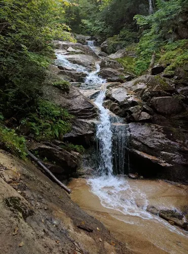
The saved photograph shows water cascading over rock steps into a small pool, with wooded slopes around it. It illustrates the trail's water scenery, not permission to bathe or proof of an easy family descent. Use the current route map and posted directions, keep to authorized paths, and do not climb the wet rocks or treat an old photograph as a current trail or water-condition report.
Use the current NH State Parks Falling Waters map with the September 2026 alignment and signed falls spur. Old junction-count directions and unchanged third-party app tracks may be inaccurate.
Use the current NH State Parks Falling Waters map with the September 2026 alignment and signed falls spur. Old junction-count directions and unchanged third-party app tracks may be inaccurate.
Confirm the entrance, parking arrangements, and legal access with the land manager. A map pin does not establish a public right of access. Follow posted routes and never block gates or driveways.
Follow the current trail and falls spur. Do not treat toddler-friendly, natural-slide or safe-depth claims from the old report as current guidance. Public park access does not necessarily include permission to swim. Respect private property and posted restrictions.
Water conditions can change quickly. This listing does not provide a current safety or water-quality assessment. Check official alerts and avoid entering water when conditions or permission are uncertain.
Nearby places from saved public map data, not necessarily facilities at the swimming spot. Confirm access, hours, fees, and amenities with the operator before you drive.
Map data retrieved 2026-06-15
Hiking area
Lincoln, NH 03251
Hiking area
Franconia, NH 03580
Campground
2 Franconia Notch State Park, Franconia, NH 03580
State park
Flume Gorge, Daniel Webster Hwy, Lincoln, NH 03251
Swimming, skiing, hiking, canoeing & history inside a mountain pass with a scenic aerial tramway.
Hiking area
Franconia, NH 03580
Public bathroom
Styles Bridges Hwy, I-93, Lincoln, NH 03251
Parking lot
Unnamed Road, Franconia, NH 03580
Scenic spot
Pemi Trail, Franconia, NH 03580
The archive describes scattered brook wading spots rather than a distinct swimming area. Current manager bathing permission at those spots has not been confirmed.
Yes. NH State Parks publishes a September 2026 alignment map with a new route and falls spur. Use that map and current signs.
The state's trail-map page warns that apps may not reflect the route change. Download the current park map rather than following an old junction count.
No. The old description is not a present assessment of crossings, rocks or current. Plan the hike for your party's actual abilities without promising a safe wading pool.
Echo Lake Beach at 260 Tramway Drive explicitly offers swimming. Its admission, reservations and operating schedule are separate from Falling Waters.
No. It establishes a changed trail alignment. Check destination-specific current notices instead of inferring a park-wide closure or guaranteed reopening.
Historical directions are retained separately; use current manager instructions for travel.
The reviewed gallery shows a cascade and rock-lined pool along the trail collection, not a verified bathing entrance or a toddler-suitable descent. Follow the current route map and stay on permitted paths.
Follow current manager routes and fire restrictions, respect private parcels and pack out waste.
Browse every listed natural swimming spot in New Hampshire.
See under-the-radar places and local favorites in the same state.
Compare easier-access destinations and safer planning options.
Explore waterfall-focused swimming destinations in New Hampshire.
Use this safety guide before entering any natural water.
Safety & Access Notice
This information is for general planning only and may be incomplete, outdated, or inaccurate. Access rules, closures, water levels, currents, hazards, and legal restrictions can change at any time. Always verify current rules with the land manager or official source before visiting.
You are responsible for your own safety and for following all posted signs, laws, and local regulations. Read the full disclaimer.
Reserve any Franconia Notch campground separately; no waterside camping permission established along this route.
Loading weather data…
Safety & Access Notice
This information is for general planning only and may be incomplete, outdated, or inaccurate. Access rules, closures, water levels, currents, hazards, and legal restrictions can change at any time. Always verify current rules with the land manager or official source before visiting.
You are responsible for your own safety and for following all posted signs, laws, and local regulations. Read the full disclaimer.
Joshua Havens created Hidden Swimming Holes to make it easier for people to find — and safely visit — natural freshwater swimming destinations across the United States. He researches access conditions, water quality resources, and land management rules so you don't have to start from scratch. He holds a strong belief that good outdoor recreation information should be accurate, honest about its limitations, and freely available.
Discover other amazing natural swimming destinations across America