Silver Lake Mountain Trailhead
Hiking area
4.7 (48)
Silver Lake Mountain Trail, Au Sable Forks, NY 12912

Background: generated illustration, not a photograph of this location.
Find the town-recognized swimming area upstream of Jay's covered bridge, while keeping the old Ausable Forks Dam route and unverified bank access separate.
Swimming restriction
Use only lawful public access and obey current signs. The covered bridge is for pedestrian/bicycle passage, not a jumping platform. Keep the historical Dam route separate from Jay's recognized swimming area.
Location
A closer look
Photos show past visits, not current water levels or swimming conditions. Select a photo to view it larger.
This is a desk-researched listing. A record update or map check does not confirm current swimming permission or water conditions.
Found an error? Send a correction with the location and a source. How we research listings.
Only the historical stop called THE DAM near Ausable Forks survives in the preserved directions. Its current lawful bathing entrance remains unresolved. Separately, the Town of Jay recognizes swimming upstream of the covered bridge at Douglas Memorial Park; this useful modern option is not the old Dam relocated or five recovered sites.
The Town of Jay describes Douglas Memorial Park and the swimming area upstream of its covered bridge. Park picnic and recreation facilities make this a more concrete planning choice than an unidentified bank. Follow current posted boundaries; town recognition does not measure today's depth, current or water quality.
The archived Mill Road approach near Ausable Forks is not the Jay covered bridge. No current manager confirmation of its parking, bank route or bathing permission was established. Do not follow an old dam-side shortcut or transfer Jay's facilities to it.
A covered bridge and attractive rock pools do not establish jumping permission or underwater clearance. Use a buddy, suitable flotation and an exit plan; avoid high or rising flow. Public navigation rights also do not authorize crossing private land to reach or leave the water.
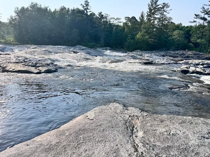
The gallery illustrates the separately named modern Jay option, with flowing water across broad rock shelves. The town recognizes swimming upstream of its covered pedestrian bridge, but the image does not locate the old Dam near Ausable Forks or make today's conditions suitable. Use the actual public park approach and posted boundaries; do not jump from the bridge or infer depth from the water's appearance.
For the current town-recognized option, use Town of Jay directions to Douglas Memorial Park and the covered bridge, then follow posted public access. Do not use the old Mill Road Dam approach without confirming owner permission and current access.
For the current town-recognized option, use Town of Jay directions to Douglas Memorial Park and the covered bridge, then follow posted public access. Do not use the old Mill Road Dam approach without confirming owner permission and current access.
Confirm the entrance, parking arrangements, and legal access with the land manager. A map pin does not establish a public right of access. Follow posted routes and never block gates or driveways.
Use only lawful public access and obey current signs. The covered bridge is for pedestrian/bicycle passage, not a jumping platform. Keep the historical Dam route separate from Jay's recognized swimming area. Public park access does not necessarily include permission to swim. Respect private property and posted restrictions.
Water conditions can change quickly. This listing does not provide a current safety or water-quality assessment. Check official alerts and avoid entering water when conditions or permission are uncertain.
Bring sturdy water shoes to protect your feet on rocks and slippery surfaces. A waterproof dry bag keeps your phone, keys, and valuables safe. Pack a quick-dry towel, sun protection, and drinking water - never drink from the natural water source.
Nearby places from saved public map data, not necessarily facilities at the swimming spot. Confirm access, hours, fees, and amenities with the operator before you drive.
Map data retrieved 2026-06-15
Hiking area
Silver Lake Mountain Trail, Au Sable Forks, NY 12912
Campground
611 Union Falls Rd, Au Sable Forks, NY 12912
Campground
367 State Hwy 9N, Keeseville, NY 12944
Parking lot
24-78 Ausable Rd, Keene Valley, NY 12943
Campground
2144 US-9, Ausable Chasm, NY 12911
Scenic canyon hosts activities from tours & cliff hikes to mountain biking & river rafting.
Campground
3346 Lakeshore Drive, Peru, NY 12972
The Town of Jay identifies swimming upstream of the covered bridge at Douglas Memorial Park. Use current posted public access and conditions.
No. The surviving archive describes THE DAM near Ausable Forks, not Jay's covered bridge.
No. Only the Dam description survives. Jay is an explicitly separate current regional option, not proof of four missing historical stops.
The town lists a pavilion, picnic benches, courts and a walking path. Do not assign those amenities to the old Dam.
No jumping authorization is established. Its pedestrian/bicycle role does not make it a diving platform, and water depth is not surveyed here.
No. DEC explains that public navigation rights do not generally authorize crossing private land to enter or leave a waterway. Obtain lawful access and any required permission.
Historical directions are retained separately; use current manager instructions for travel.
The gallery illustrates the separately named Jay option on the East Branch AuSable, with rock shelves and flowing water. It is not the historical Dam near Ausable Forks, a relocated archive pin or a present depth and current assessment.
Follow current manager routes and fire restrictions, respect private parcels and pack out waste.
Browse every listed natural swimming spot in New York.
Find similar regional river listing with one current town-recognized alternative destinations across the directory.
See under-the-radar places and local favorites in the same state.
Compare easier-access destinations and safer planning options.
Use this safety guide before entering any natural water.
Safety & Access Notice
This information is for general planning only and may be incomplete, outdated, or inaccurate. Access rules, closures, water levels, currents, hazards, and legal restrictions can change at any time. Always verify current rules with the land manager or official source before visiting.
You are responsible for your own safety and for following all posted signs, laws, and local regulations. Read the full disclaimer.
No camping authorization established at either bathing approach.
Loading weather data…
Safety & Access Notice
This information is for general planning only and may be incomplete, outdated, or inaccurate. Access rules, closures, water levels, currents, hazards, and legal restrictions can change at any time. Always verify current rules with the land manager or official source before visiting.
You are responsible for your own safety and for following all posted signs, laws, and local regulations. Read the full disclaimer.
Joshua Havens created Hidden Swimming Holes to make it easier for people to find — and safely visit — natural freshwater swimming destinations across the United States. He researches access conditions, water quality resources, and land management rules so you don't have to start from scratch. He holds a strong belief that good outdoor recreation information should be accurate, honest about its limitations, and freely available.
Discover other amazing natural swimming destinations across America