Looking Glass Falls Parking
Parking lot
4.7 (36)
Unnamed Road, Brevard, NC 28712

Background: generated illustration, not a photograph of this location.
Plan the Looking Glass Rock overlook at Blue Ridge Parkway milepost 417. The incomplete regional record does not identify four verified swimming stops.
Swimming permission unconfirmed
Use authorized entrances and obey current notices. Do not jump, dive or use rope swings or natural rock slides.
Status summarizes our reviewed record, not today's opening or safety. Check current rules, swimming boundaries and notices before visiting.
Location
A closer look
Photos show past visits, not current water levels or swimming conditions. Select a photo to view it larger.
Resized and converted to WebP; embedded metadata removed; scene content unchanged
This is a desk-researched listing. A record update or map check does not confirm current swimming permission or water conditions.
Found an error? Send a correction with the location and a source. How we research listings.
The original directions begin at Looking Glass Rock Overlook, Blue Ridge Parkway milepost 417, then stop before identifying the four claimed water destinations. This is not a complete four-pool itinerary. The overlook, the rock’s summit trail and Looking Glass Falls are different destinations.
NPS identifies milepost 417 as a scenic overlook with vehicle parking, interpretive information, views and a trailhead. Plan a permitted viewpoint visit if you have not chosen and checked a separate waterfall or water-entry destination. Overlook amenities do not establish bathing facilities below the Parkway.
The NPS road-status page dated October 13, 2026 lists mileposts 411.9-418.7 open. That includes the overlook’s milepost, but it is a dated road report, not a guarantee of access on your visit or of any nearby pool’s condition. Recheck weather, road and trail notices before leaving.
If your goal is a waterfall hike or swimming, identify the exact site, land manager, trailhead and activity rules first. Do not add familiar nearby waterfalls to the missing historical sequence or rely on an old regional coordinate as a safe water entrance.
Allow time for parking and a turnaround, carry drinking water and keep a scenic shore or overlook alternative. Observe barriers and private-property boundaries. Do not climb wet waterfall rocks, jump, dive or assume an unmarked path is open after storms.
NPS overlook information and Parkway road status support the named scenic stop and road planning, not the missing swimming destinations.
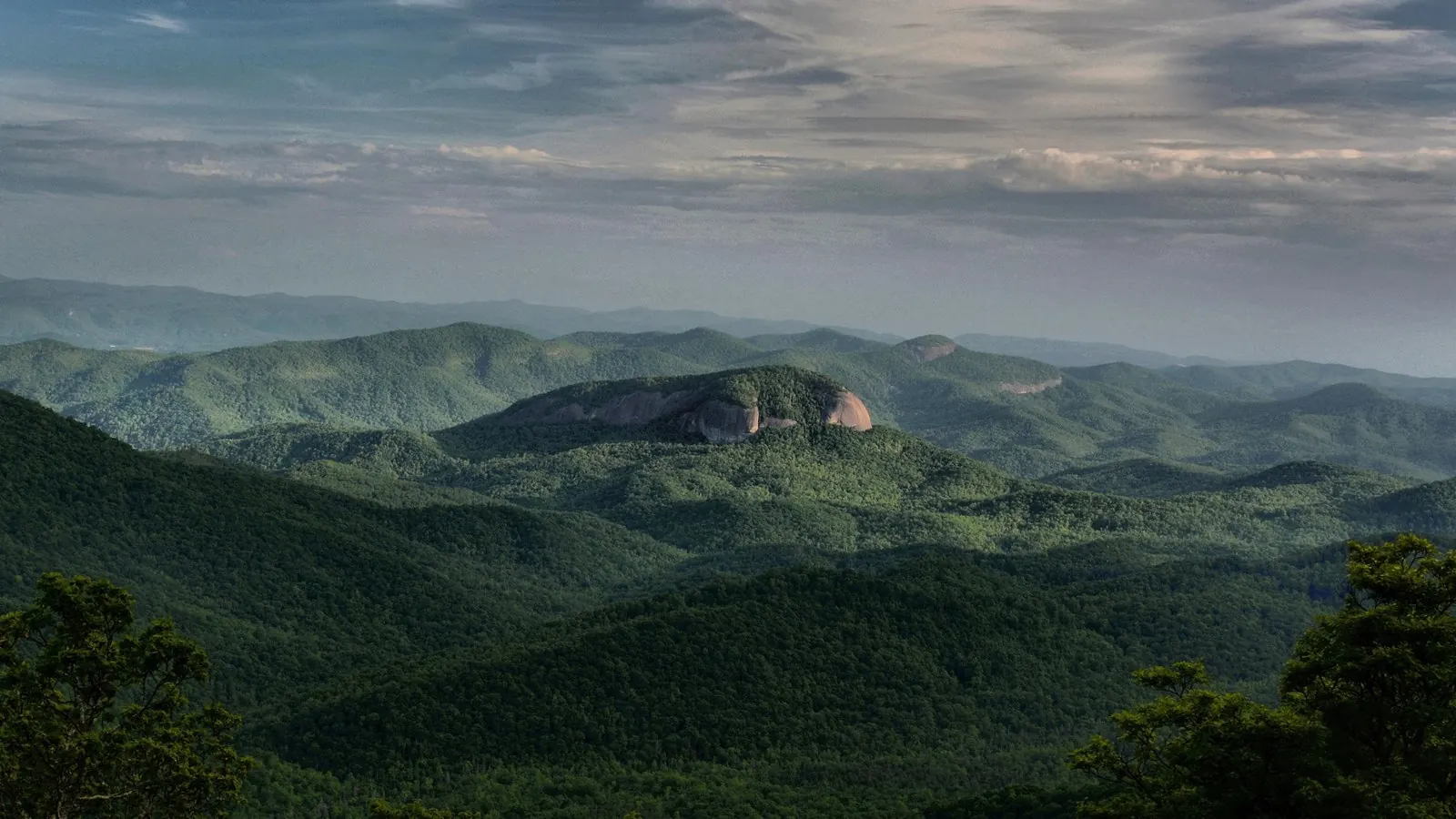
This NPS photograph shows the exposed face of Looking Glass Rock among forested mountain ridges. It helps identify the scenic landmark named in the surviving directions. It is not Looking Glass Falls, a view from the summit or evidence of the four missing water destinations in the historical record. Plan a separate, named destination for any waterfall or water activity rather than using this mountain panorama as a water-entry guide. Credit: National Park Service / A. Armstrong. The image is resized and converted to WebP; scene content is unchanged.
The original directions end after naming Looking Glass Rock Overlook at Blue Ridge Parkway milepost 417. Use NPS current road and overlook information for a scenic visit; select and verify a separate named water destination before navigating to it.
NPS October 13, 2026 road report lists 411.9-418.7 open; recheck current status. Missing bathing destinations remain unresolved.
Confirm the entrance, parking arrangements, and legal access with the land manager. A map pin does not establish a public right of access. Follow posted routes and never block gates or driveways.
Use authorized entrances and obey current notices. Do not jump, dive or use rope swings or natural rock slides. Public park access does not necessarily include permission to swim. Respect private property and posted restrictions.
Water conditions can change quickly. This listing does not provide a current safety or water-quality assessment. Check official alerts and avoid entering water when conditions or permission are uncertain.
Nearby places from saved public map data, not necessarily facilities at the swimming spot. Confirm access, hours, fees, and amenities with the operator before you drive.
Map data retrieved 2026-06-15
Parking lot
Unnamed Road, Brevard, NC 28712
Hiking area
Brevard, NC 28712
Campground
1 Davidson River Cir, Pisgah Forest, NC 28768
Forested tent & RV sites along the Davidson River, with available hot showers & flush toilets.
Campground
129 Israel Rd, Brevard, NC 28712
Campground
15 La Salle Dr, Pisgah Forest, NC 28768
Public bathroom
Brevard, NC 28712
Tourist information center
1600 Pisgah Hwy, Pisgah Forest, NC 28768
No. It names the starting overlook at milepost 417 but stops before individual destinations.
No. The scenic overlook, summit trail and waterfall are separate destinations with different approaches.
Vehicle parking, interpretive information, scenic views and a trailhead. These are not verified swimming facilities.
The NPS report dated October 13, 2026 lists mileposts 411.9-418.7 open. Recheck the current road page; that report does not certify nearby trail or water access.
No exact bathing entrance is established. Select a named water destination and check its manager’s current route and activity rules.
Plan a permitted overlook visit or a separately source-checked trail, with current access notices and a turnaround plan.
Respect protected sites and local rules; no invented cultural associations.
This NPS photograph shows the exposed face of Looking Glass Rock among forested mountain ridges. It helps identify the scenic landmark named in the surviving directions. It is not Looking Glass Falls, a view from the summit or evidence of the four missing water destinations in the historical record. Plan a separate, named destination for any waterfall or water activity rather than using this mountain panorama as a water-entry guide. Credit: National Park Service / A. Armstrong. The image is resized and converted to WebP; scene content is unchanged.
Respect property boundaries, use authorized routes and carry out waste.
Browse every listed natural swimming spot in North Carolina.
See under-the-radar places and local favorites in the same state.
Compare easier-access destinations and safer planning options.
Use this safety guide before entering any natural water.
Safety & Access Notice
This information is for general planning only and may be incomplete, outdated, or inaccurate. Access rules, closures, water levels, currents, hazards, and legal restrictions can change at any time. Always verify current rules with the land manager or official source before visiting.
You are responsible for your own safety and for following all posted signs, laws, and local regulations. Read the full disclaimer.
Book an authorized campground separately; no assumed overnight riverbank access.
Loading weather data…
Safety & Access Notice
This information is for general planning only and may be incomplete, outdated, or inaccurate. Access rules, closures, water levels, currents, hazards, and legal restrictions can change at any time. Always verify current rules with the land manager or official source before visiting.
You are responsible for your own safety and for following all posted signs, laws, and local regulations. Read the full disclaimer.
Joshua Havens created Hidden Swimming Holes to make it easier for people to find — and safely visit — natural freshwater swimming destinations across the United States. He researches access conditions, water quality resources, and land management rules so you don't have to start from scratch. He holds a strong belief that good outdoor recreation information should be accurate, honest about its limitations, and freely available.
Discover other amazing natural swimming destinations across America