Marienville Ranger Station
Visitor center
4.5 (55)
131 Smokey Lane, Marienville, PA 16239
Restroom

Background: generated illustration, not a photograph of this location.
Plan Loleta's designated seasonal swimming area, bathhouse and campground separately. The generic Site Open label does not extend its published beach season.
Swimming restriction
Manager explicitly lists swimming at the seasonal recreation area. This does not authorize arbitrary creek pools, rock jumping or a year-round bathing session.
Official sources checked:
Location
A closer look
Photos show past visits, not current water levels or swimming conditions. Select a photo to view it larger.
This is a desk-researched listing. A record update or map check does not confirm current swimming permission or water conditions.
Found an error? Send a correction with the location and a source. How we research listings.
Loleta's Forest Service recreation area includes a reconstructed mill pond, swimming area and CCC-era bathhouse setting. This is more specific than the old description of finding varied creek pools near the Upper Camping Loop. Use the designated swimming area and current manager directions, not an unsigned campground turn as a water-entry plan.
The current page carries a generic Site Open label but separately lists swimming/picnicking May 26-September 4, day use May 1-October 10 and camping April 1-October 10. On October 14 that label alone does not establish an operating beach. Confirm present or future operation with the Marienville district rather than assume year-round swimming.
Use the current Forest Service map and Loleta recreation entrance south of Marienville. Identify the designated beach rather than follow the old unsigned Upper Camping Loop suggestion.
Manager lists toilets, hand-pump drinking water, picnic tables and shelters, plus a bathhouse with changing and washing facilities. Confirm which seasonal facilities are operating. Manager lists $5 vehicle day use/$65 seasonal pass; camping charges are separate. Confirm current rates and actual operation before paying or travelling.
Manager explicitly lists swimming at the seasonal recreation area. This does not authorize arbitrary creek pools, rock jumping or a year-round bathing session. Published swim/picnic May 26-September 4, day use May 1-October 10, camping April 1-October 10. Generic Site Open does not establish October beach operation; confirm directly. Manager describes upper/lower loops and reserved group sites; some lower-loop sites have electricity. Book the actual campsite under its own season and current availability.
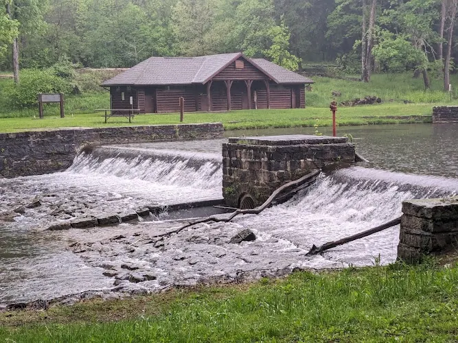
The saved photograph shows a log bathhouse behind the stone dam and spillway, consistent with the manager's description of Loleta's historic recreation facilities. It provides architectural context, not a current pool-depth, flow or water-quality assessment. Do not use the spillway as a water entrance or infer a swimming opening from this historical scene; follow the actual designated area, seasonal notice and current signs.
Use the current Forest Service map and Loleta recreation entrance south of Marienville. Identify the designated beach rather than follow the old unsigned Upper Camping Loop suggestion.
Use the current Forest Service map and Loleta recreation entrance south of Marienville. Identify the designated beach rather than follow the old unsigned Upper Camping Loop suggestion.
Confirm the entrance, parking arrangements, and legal access with the land manager. A map pin does not establish a public right of access. Follow posted routes and never block gates or driveways.
Manager explicitly lists swimming at the seasonal recreation area. This does not authorize arbitrary creek pools, rock jumping or a year-round bathing session. Public park access does not necessarily include permission to swim. Respect private property and posted restrictions.
Water conditions can change quickly. This listing does not provide a current safety or water-quality assessment. Check official alerts and avoid entering water when conditions or permission are uncertain.
Bring sturdy water shoes to protect your feet on rocks and slippery surfaces. A waterproof dry bag keeps your phone, keys, and valuables safe. Pack a quick-dry towel, sun protection, and drinking water - never drink from the natural water source.
Nearby places from saved public map data, not necessarily facilities at the swimming spot. Confirm access, hours, fees, and amenities with the operator before you drive.
Map data retrieved 2026-06-15
Visitor center
131 Smokey Lane, Marienville, PA 16239
Park
Warren, PA 16365
Campground
342 River Rd, Warren, PA 16365
Parking garage
11 Clark St, Warren, PA 16365
Public bathroom
Warren, PA 16365
Parking lot
2nd Ave, Warren, PA 16365
Tourist information center
22045 US-6, Warren, PA 16365
Park
Warren/North Warren Bike Trail, Warren, PA 16365
Yes. The Forest Service identifies a reconstructed mill pond, seasonal swimming area and bathhouse. Use the designated area rather than seek unspecified creek pools.
No. The same page lists swimming/picnicking May 26-September 4 and shorter separate facility seasons. Confirm operation directly; the generic label does not extend the bathing calendar.
Use the current recreation map and designated swimming entrance instead. Camping loops are not a substitute for confirmed beach directions.
The manager lists toilets and hand-pump drinking water, plus bathhouse facilities. Seasonal operation must be confirmed before relying on those services.
The page lists a vehicle day-use fee, with separate campsite charges. Confirm the current rate and opening rather than advertise free year-round bathing.
No. Electrical hookups, group facilities and other services belong to the named recreation area and actual campsite, not arbitrary creek frontage.
Historical directions preserved separately, not presented as current visitor authorization.
The gallery shows the historic bathhouse and stone mill-pond works, not a mapped bathing entry or current opening. The spillway is not a recommended route into the water.
Use authorized routes, respect private property and closures, protect creek banks and pack out waste.
Browse every listed natural swimming spot in Pennsylvania.
Find similar pool destinations across the directory.
See under-the-radar places and local favorites in the same state.
Compare easier-access destinations and safer planning options.
Use this safety guide before entering any natural water.
Safety & Access Notice
This information is for general planning only and may be incomplete, outdated, or inaccurate. Access rules, closures, water levels, currents, hazards, and legal restrictions can change at any time. Always verify current rules with the land manager or official source before visiting.
You are responsible for your own safety and for following all posted signs, laws, and local regulations. Read the full disclaimer.
Manager describes upper/lower loops and reserved group sites; some lower-loop sites have electricity. Book the actual campsite under its own season and current availability.
Loading weather data…
Safety & Access Notice
This information is for general planning only and may be incomplete, outdated, or inaccurate. Access rules, closures, water levels, currents, hazards, and legal restrictions can change at any time. Always verify current rules with the land manager or official source before visiting.
You are responsible for your own safety and for following all posted signs, laws, and local regulations. Read the full disclaimer.
Joshua Havens created Hidden Swimming Holes to make it easier for people to find — and safely visit — natural freshwater swimming destinations across the United States. He researches access conditions, water quality resources, and land management rules so you don't have to start from scratch. He holds a strong belief that good outdoor recreation information should be accurate, honest about its limitations, and freely available.
Discover other amazing natural swimming destinations across America