Kisatchie Bayou Campground
Campground
4.7 (186)
Provencal, LA 71468
Public restroomPublic showerRestroomRunning water

Background: generated illustration, not a photograph of this location.
Kisatchie Bayou: Swimming, Day Use and Primitive Camping. Current access, parking and manager-specific services for planning a responsible visit.
Swimming restriction
Manager-listed swimming, nonmotorized boating, fishing, hiking and picnicking, subject to current notices and bayou conditions. Current manager page marks site open, with day-use operational hours 24 hours a day. Check alerts and river conditions before swimming; this is not a daily water-quality guarantee.
Official sources checked:
Location
A closer look
Photos show past visits, not current water levels or swimming conditions. Select a photo to view it larger.
This is a desk-researched listing. A record update or map check does not confirm current swimming permission or water conditions.
Found an error? Send a correction with the location and a source. How we research listings.
Kisatchie Bayou Recreation Complex is a Forest Service destination southwest of Natchitoches, with swimming listed among its water activities. Rocky bayou scenery, a developed day-use area and primitive camping make it useful for a combined picnic and outdoor visit, without implying uniform depth or clean water in every reach.
The current Forest Service page marks the site open and publishes a $2 day-use fee. It describes 17 walk-in campsites and one drive-in site at the middle parking area. Recreation.gov says campsites are first come, first served: arrive to claim a site rather than assuming an online reservation.
No water is available at the campground. Day use has vault restrooms, picnic tables, fire rings and trash receptacles; campsites have tent pads, barbecue pits and lantern posts. These are primitive services, not a bathhouse, food concession or lifeguarded pool.
Access steps lead from the lower parking area to the bank for canoe unloading. Check local conditions and posted swimming notices before entering; rocky rapids, slippery banks and changing flow call for caution. The district brochure's camping rate is $2 per night, but confirm the posted fee when you arrive.
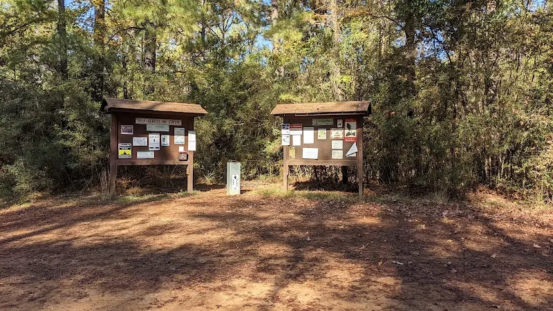
The historical photograph shows two wooden notice boards and a self-service post in a wooded arrival area. It helps illustrate the visitor-information setting, not the bayou swimming entrance or an available campsite. Read the actual notices on arrival for current fees, payment instructions and restrictions; an old photograph is not a current notice or proof that drinking water is available.
Use the current Forest Service destination instructions and map for the Longleaf Scenic Byway approach and Forest Roads 321 and 366. Choose the day-use parking or campground deliberately; download the route before losing cell service.
Use the current Forest Service destination instructions and map for the Longleaf Scenic Byway approach and Forest Roads 321 and 366. Choose the day-use parking or campground deliberately; download the route before losing cell service.
Confirm the entrance, parking arrangements, and legal access with the land manager. A map pin does not establish a public right of access. Follow posted routes and never block gates or driveways.
Manager-listed swimming, nonmotorized boating, fishing, hiking and picnicking, subject to current notices and bayou conditions. Current manager page marks site open, with day-use operational hours 24 hours a day. Check alerts and river conditions before swimming; this is not a daily water-quality guarantee. Public park access does not necessarily include permission to swim. Respect private property and posted restrictions.
Water conditions can change quickly. This listing does not provide a current safety or water-quality assessment. Check official alerts and avoid entering water when conditions or permission are uncertain.
Bring sturdy water shoes to protect your feet on rocks and slippery surfaces. A waterproof dry bag keeps your phone, keys, and valuables safe. Pack a quick-dry towel, sun protection, and drinking water - never drink from the natural water source.
Nearby places from saved public map data, not necessarily facilities at the swimming spot. Confirm access, hours, fees, and amenities with the operator before you drive.
Map data retrieved 2026-06-15
Campground
Provencal, LA 71468
Hiking area
F S 361, Provencal, LA 71468
Hiking area
Montrose Rd, Natchitoches, LA 71457
Hiking area
Unnamed Road, Natchitoches, LA 71457
Campground
140 LA-120, Natchitoches, LA 71457
Campground
5428 University Pkwy, Natchitoches, LA 71457
Non-profit organization
4115 University Pkwy, Natchitoches, LA 71457
Public bathroom
155 Jefferson St, Natchitoches, LA 71457
Swimming is listed on the current Kisatchie Bayou recreation page. Check current notices and conditions at the intended entry; that activity listing does not make every rapid or pool safe.
The current Forest Service page publishes a $2 day-use fee. Its district brochure lists $2 per night for camping, which should be checked against current on-site instructions.
Recreation.gov describes this campground as first come, first served. Arrive to claim and pay for a site; do not interpret its listing as a confirmed reservation.
No. The Forest Service expressly says no water is available at the campground. Bring your own drinking water.
The manager lists vault restrooms, picnic tables, fire rings and trash receptacles. Access steps to the bayou assist canoe unloading; no lifeguard service is advertised.
No. The current manager describes 17 walk-in sites and one drive-in site at the middle parking area. Pack for carrying equipment and check your route before arrival.
Historical directions are retained separately; use current manager instructions for travel.
The reviewed historical gallery shows visitor information boards and a self-service post, not a water entrance or campsite. Use the current posted notices and payment instructions instead of reading old fees from the photograph.
Follow current manager routes and fire restrictions, respect private parcels and pack out waste.
Browse every listed natural swimming spot in Louisiana.
Find similar forest service day-use and primitive camping complex destinations across the directory.
See under-the-radar places and local favorites in the same state.
Compare easier-access destinations and safer planning options.
Use this safety guide before entering any natural water.
Safety & Access Notice
This information is for general planning only and may be incomplete, outdated, or inaccurate. Access rules, closures, water levels, currents, hazards, and legal restrictions can change at any time. Always verify current rules with the land manager or official source before visiting.
You are responsible for your own safety and for following all posted signs, laws, and local regulations. Read the full disclaimer.
Primitive campground: 17 walk-in sites and one drive-in site. First come, first served on Recreation.gov; Scan and Pay may be available after arrival.
Loading weather data…
Safety & Access Notice
This information is for general planning only and may be incomplete, outdated, or inaccurate. Access rules, closures, water levels, currents, hazards, and legal restrictions can change at any time. Always verify current rules with the land manager or official source before visiting.
You are responsible for your own safety and for following all posted signs, laws, and local regulations. Read the full disclaimer.
Joshua Havens created Hidden Swimming Holes to make it easier for people to find — and safely visit — natural freshwater swimming destinations across the United States. He researches access conditions, water quality resources, and land management rules so you don't have to start from scratch. He holds a strong belief that good outdoor recreation information should be accurate, honest about its limitations, and freely available.
Discover other amazing natural swimming destinations across America