Farquar-Metsa Tourist Park
Campground
4.5 (138)
150 W Iron St, Gwinn, MI 49841
Picnic tablesPublic restroom

Background: generated illustration, not a photograph of this location.
Farquar-Metsa Park: Escanaba River Swimming and Campground Rules. Confirm the exact entrance, manager rules, fees and services before travel.
Swimming restriction
Manager-listed swimming, fishing, hiking, canoeing, bicycling and picnicking; confirm intended authorized swimming bank and current conditions. Manager publishes park closure 10 p.m. to 7 a.m.; confirm seasonal campsite and swimming availability with host.
Official sources checked:
Location
A closer look
Photos show past visits, not current water levels or swimming conditions. Select a photo to view it larger.
This is a desk-researched listing. A record update or map check does not confirm current swimming permission or water conditions.
Found an error? Send a correction with the location and a source. How we research listings.
Farquar-Metsa Tourist Park in Gwinn is a Forsyth Township destination on the Escanaba River. The current township page explicitly includes swimming among its amenities, alongside fishing, hiking, canoeing and day-use picnic space. Its campground is a separate booked stay, not evidence that every river reach is a beach.
The manager lists 150 W Iron Street, Gwinn, and reservations/information at 906-250-1081. Confirm the day-use swimming approach and any registration or fee requirement with the host; do not guess that campground booking is mandatory for every daytime visit.
The township lists 20 full-hookup sites, two electric-only sites and 13 primitive tent sites, with reservations required. Hot showers, restrooms, Wi-Fi and a dump station are campground services. Confirm how day visitors may use them rather than promising unrestricted pool-side amenities.
The manager says the park is closed from 10 p.m. to 7 a.m., with 3 p.m. check-in and 1 p.m. checkout for camping. Its current page links a rules document labelled 2023, so ask the host about current pet/visitor restrictions and rates. Swimming is supported, but no lifeguard service, inspected jumping ledge or current water-quality clearance is advertised.
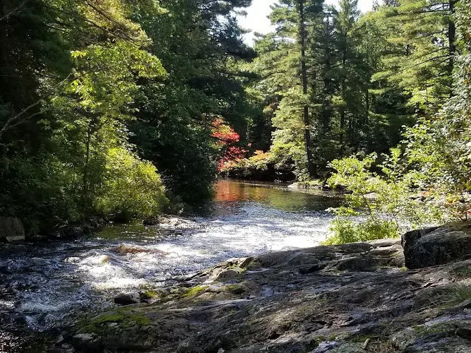
The historical photograph shows moving water, exposed rock ledges and a wooded bank. It adds river-setting context, not a surveyed bathing approach or permission to jump from the rocks. The township's swimming activity listing remains separate from the condition of this pictured reach. Ask about current access and conditions, and do not infer water depth, a clear landing or campground availability from the photograph.
Use the current township address 150 W Iron Street, Gwinn, and ask the campground host for day-use water access. Do not replace this park with a similarly spelled or differently located record.
Use the current township address 150 W Iron Street, Gwinn, and ask the campground host for day-use water access. Do not replace this park with a similarly spelled or differently located record.
Confirm the entrance, parking arrangements, and legal access with the land manager. A map pin does not establish a public right of access. Follow posted routes and never block gates or driveways.
Manager-listed swimming, fishing, hiking, canoeing, bicycling and picnicking; confirm intended authorized swimming bank and current conditions. Manager publishes park closure 10 p.m. to 7 a.m.; confirm seasonal campsite and swimming availability with host. Public park access does not necessarily include permission to swim. Respect private property and posted restrictions.
Water conditions can change quickly. This listing does not provide a current safety or water-quality assessment. Check official alerts and avoid entering water when conditions or permission are uncertain.
Bring sturdy water shoes to protect your feet on rocks and slippery surfaces. A waterproof dry bag keeps your phone, keys, and valuables safe. Pack a quick-dry towel, sun protection, and drinking water - never drink from the natural water source.
Nearby places from saved public map data, not necessarily facilities at the swimming spot. Confirm access, hours, fees, and amenities with the operator before you drive.
Map data retrieved 2026-06-15
Campground
150 W Iron St, Gwinn, MI 49841
Nature preserve
230 N Southgate Dr, Gwinn, MI 49841
Park
115 N Pine St, Gwinn, MI 49841
Government office
410 W State Highway, M-35, Gwinn, MI 49841
Parking lot
257 M-35, Gwinn, MI 49841
Campground
Gwinn, MI 49841
Campground
Gwinn, MI 49841
Public bathroom
112 Morgan Meadows Rd, Marquette, MI 49855
Yes. Forsyth Township lists swimming on the Escanaba River among park amenities. Confirm the intended bank, current flow and any posted restrictions.
The current page requires camping reservations but does not resolve every day-use swimming registration term. Ask the host rather than assuming a campsite is necessary.
The township lists 150 W Iron Street, Gwinn. The published reservations and information number is 906-250-1081.
The manager lists 20 full-hookup sites, two electric-only sites and 13 primitive tent sites, with reservations required.
The campground advertises hot showers and restrooms. Confirm whether day visitors may use campground services; they should not be assigned to every riverbank.
The township says the park is closed from 10 p.m. to 7 a.m. Camping check-in is 3 p.m. and checkout 1 p.m.; confirm arrangements with the host.
Historical directions are retained separately; use current manager instructions for travel.
The reviewed historical gallery shows a wooded river setting and exposed ledges. It does not establish a designated entry, clear landing, campsite availability or today's river conditions.
Follow current manager routes and fire restrictions, respect private parcels and pack out waste.
Browse every listed natural swimming spot in Michigan.
Compare nearby options around Marquette before you choose a route.
Find similar township river park and booked campground destinations across the directory.
See under-the-radar places and local favorites in the same state.
Compare easier-access destinations and safer planning options.
Use this safety guide before entering any natural water.
Safety & Access Notice
This information is for general planning only and may be incomplete, outdated, or inaccurate. Access rules, closures, water levels, currents, hazards, and legal restrictions can change at any time. Always verify current rules with the land manager or official source before visiting.
You are responsible for your own safety and for following all posted signs, laws, and local regulations. Read the full disclaimer.
Reservations required: 20 full-hookup sites, two electric-only sites, 13 primitive tent sites. Published check-in 3 p.m., checkout 1 p.m.
Loading weather data…
Safety & Access Notice
This information is for general planning only and may be incomplete, outdated, or inaccurate. Access rules, closures, water levels, currents, hazards, and legal restrictions can change at any time. Always verify current rules with the land manager or official source before visiting.
You are responsible for your own safety and for following all posted signs, laws, and local regulations. Read the full disclaimer.
Joshua Havens created Hidden Swimming Holes to make it easier for people to find — and safely visit — natural freshwater swimming destinations across the United States. He researches access conditions, water quality resources, and land management rules so you don't have to start from scratch. He holds a strong belief that good outdoor recreation information should be accurate, honest about its limitations, and freely available.
Discover other amazing natural swimming destinations across America