Richardson Creek Trailhead
Hiking area
4.8 (25)
Clear Spring Rd, Roxie, MS 39661

Background: generated illustration, not a photograph of this location.
Plan Clear Springs Recreation Area in Homochitto National Forest with supported swimming, campground services, fees and beach-access limitations.
Swimming restriction
Use authorized entrances and obey current notices. Do not jump, dive or use rope swings or natural rock slides.
Official sources checked:
Location
A closer look
Photos show past visits, not current water levels or swimming conditions. Select a photo to view it larger.
This is a desk-researched listing. A record update or map check does not confirm current swimming permission or water conditions.
Found an error? Send a correction with the location and a source. How we research listings.
Clear Springs Recreation Area near Meadville is a Homochitto National Forest lake destination. The Forest Service's March 2026 page explicitly lists swimming, camping, fishing and picnicking and marks the site open. An open-site label is not today's water-quality clearance or a guarantee that every facility is operating.
The manager describes accessible cement routes between parking, pavilion, amphitheater and restrooms, plus accessible bathhouses and some campsites. It specifically says there are no accessible routes to the beach or fishing areas. Steep terrain and paved roads with substantial slopes mean an accessible building should not be mistaken for an accessible water entrance.
The current Forest Service amenity information says potable water is unavailable, despite an older brochure describing drinking water. Bring your own and confirm current supplies. Day use is posted at $5 per vehicle, with pass provisions; electric-hookup camping is listed separately. Recreation.gov describes first-come individual campsites and separate group reservations. Boat trailers are prohibited. Use the current Clear Springs Road approach from US 84 and check notices rather than treating year-round campground use as guaranteed swimming conditions.
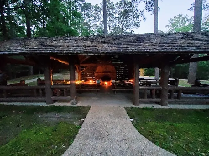
The saved gallery shows a covered log pavilion with tables and a paved approach. This adds useful recreation-area context, but it does not establish an accessible route into the lake, a pavilion reservation or current drinking-water availability. The fire visible in the photograph is not today's fire permission. Confirm the facilities and current restrictions for your visit, and keep swimming conditions separate from campground scenery.
From US 84 west of Meadville, use Clear Springs Road (County Road 104) south for the recreation area. Confirm current Forest Service route and road notices.
Use the named recreation area and authorized activity boundaries; site-open status is not a present water-quality report. Boat trailers prohibited.
Confirm the entrance, parking arrangements, and legal access with the land manager. A map pin does not establish a public right of access. Follow posted routes and never block gates or driveways.
Use authorized entrances and obey current notices. Do not jump, dive or use rope swings or natural rock slides. Public park access does not necessarily include permission to swim. Respect private property and posted restrictions.
Water conditions can change quickly. This listing does not provide a current safety or water-quality assessment. Check official alerts and avoid entering water when conditions or permission are uncertain.
Bring sturdy water shoes to protect your feet on rocks and slippery surfaces. A waterproof dry bag keeps your phone, keys, and valuables safe. Pack a quick-dry towel, sun protection, and drinking water - never drink from the natural water source.
Nearby places from saved public map data, not necessarily facilities at the swimming spot. Confirm access, hours, fees, and amenities with the operator before you drive.
Map data retrieved 2026-06-15
Hiking area
Clear Spring Rd, Roxie, MS 39661
Campground
Clear Spring Rd, Roxie, MS 39661
Visitor center
640 S Canal St, Natchez, MS 39120
Public bathroom
Brookhaven, MS 39601
State park
2036 Percy Quin Dr, McComb, MS 39648
Over 1000 acres with golf course & convention center plus rental cabins, playgrounds & picnicking.
Park
1134 Mt Zion Rd NW, Brookhaven, MS 39601
Park
364 Hartman St, Brookhaven, MS 39601
Park
220 Linton Ave, Brookhaven, MS 39601
Yes. The current Forest Service page explicitly lists swimming at Clear Springs. Current conditions and posted notices still determine whether to enter.
The manager says there are no accessible routes to the beach or fishing areas, even though routes to several buildings and bathhouses are accessible.
The current Forest Service amenity field says potable water is unavailable; an older brochure differs. Bring your own and confirm with the ranger district.
The Forest Service posts $5 per vehicle with specified pass provisions. Camping and group-use products have separate charges; verify the current schedule.
Recreation.gov describes individual sites as first-come, first-served and asks visitors to claim only a vacant site. Group arrangements have separate reservation requirements.
No. The Forest Service lists boat trailers as prohibited at Clear Springs.
Respect protected sites and local rules; no invented cultural associations.
The reviewed gallery shows the covered picnic pavilion and its approach, not a surveyed accessible swimming entrance. Check current pavilion arrangements, fire restrictions, water services and beach conditions separately.
Respect property boundaries, use authorized routes and carry out waste.
Browse every listed natural swimming spot in Mississippi.
Find similar spring-fed lake recreation area destinations across the directory.
See under-the-radar places and local favorites in the same state.
Compare easier-access destinations and safer planning options.
Use this safety guide before entering any natural water.
Safety & Access Notice
This information is for general planning only and may be incomplete, outdated, or inaccurate. Access rules, closures, water levels, currents, hazards, and legal restrictions can change at any time. Always verify current rules with the land manager or official source before visiting.
You are responsible for your own safety and for following all posted signs, laws, and local regulations. Read the full disclaimer.
Authorized campground; Recreation.gov describes first-come individual sites and separate group reservation requirements.
Loading weather data…
Safety & Access Notice
This information is for general planning only and may be incomplete, outdated, or inaccurate. Access rules, closures, water levels, currents, hazards, and legal restrictions can change at any time. Always verify current rules with the land manager or official source before visiting.
You are responsible for your own safety and for following all posted signs, laws, and local regulations. Read the full disclaimer.
Joshua Havens created Hidden Swimming Holes to make it easier for people to find — and safely visit — natural freshwater swimming destinations across the United States. He researches access conditions, water quality resources, and land management rules so you don't have to start from scratch. He holds a strong belief that good outdoor recreation information should be accurate, honest about its limitations, and freely available.
Discover other amazing natural swimming destinations across America