Rock Creek Campground
Campground
4.5 (124)
NE Dole Valley Rd, Yacolt, WA 98675
Public restroomRestroomRunning waterTent sites

Background: generated illustration, not a photograph of this location.
Compare Lewisville and Moulton Falls access, parking and river precautions near Battle Ground. Lucia Falls is not open for swimming.
Location
A closer look
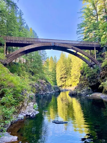
Photos show past visits, not current water levels or swimming conditions. Select a photo to view it larger.
This is a desk-researched listing. A record update or map check does not confirm current swimming permission or water conditions.
Found an error? Send a correction with the location and a source. How we research listings.
This regional guide covers separate Clark County destinations, not a single swimming hole or a verified five-stop swimming route. Lewisville and Moulton Falls provide river access, while nearby Lucia Falls must not be treated as another swimming stop. Check the relevant park page and posted restrictions before traveling.
Use 26411 NE Lewisville Highway, Battle Ground, for the park entrance. The county lists restrooms, picnic facilities and trails. Vehicle parking costs $5 daily; walking or cycling into the park is free. The park page currently reports a closure around the fire-damaged Central picnic shelter. It also warns that the East Fork Lewis River is closed downstream of Daybreak Regional Park, about three miles downstream of Lewisville. Do not plan a float through that closure.
Navigate to 27781 NE Lucia Falls Road, Yacolt. Clark County allows swimming here at the visitor's own risk, but specifically warns against jumping or diving from the arch bridge. Picnic tables and a restroom are listed. The connecting trail toward Lucia Falls is a walking option, not permission to enter the water at that destination.
Clark County prohibits swimming at Lucia Falls Regional Park to protect sensitive fish-spawning grounds. Do not use this guide's earlier wading recommendation. Enjoy the scenery from permitted land access instead.
County parks do not have lifeguards. Cold water, currents, submerged hazards and sudden depth changes remain concerns even on warm days. Bring a properly fitting life jacket, stay with companions and give children continuous attention. This guide does not certify water quality or an entry point. Battle Ground Lake State Park is a separate option with its own rules and fees; consult its operator and the county's current public-beach advisories before choosing it.
Choose a named park before navigating. Lewisville Regional Park: 26411 NE Lewisville Highway, Battle Ground, WA. Moulton Falls Regional Park: 27781 NE Lucia Falls Road, Yacolt, WA 98675. Use designated entrances and parking, then obey local signs. These addresses identify parks, not verified water-entry points. Do not follow the former generic Rock Creek Road turn instructions. Lucia Falls is not a swimming destination.
Choose a park, not a regional map pin. Respect the Central shelter closure at Lewisville and the river closure downstream of Daybreak. Check operator updates before departure.
Confirm the entrance, parking arrangements, and legal access with the land manager. A map pin does not establish a public right of access. Follow posted routes and never block gates or driveways.
Current swimming permission has not been independently confirmed for this listing. Check official rules, fees, hours, and closures before visiting. Public park access does not necessarily include permission to swim. Respect private property and posted restrictions.
Water conditions can change quickly. This listing does not provide a current safety or water-quality assessment. Check official alerts and avoid entering water when conditions or permission are uncertain.
Bring sturdy water shoes to protect your feet on rocks and slippery surfaces. A waterproof dry bag keeps your phone, keys, and valuables safe. Pack a quick-dry towel, sun protection, and drinking water - never drink from the natural water source.
Nearby places from saved public map data, not necessarily facilities at the swimming spot. Confirm access, hours, fees, and amenities with the operator before you drive.
Map data retrieved 2026-06-15
Campground
NE Dole Valley Rd, Yacolt, WA 98675
State park
33914 NW Paradise Park Rd, Ridgefield, WA 98642
Creekside state park offering 88 acres of fee-based camping with yurts available for rental.
Campground
7603 NE 13th Ave, Vancouver, WA 98665
Gated RV park offering a recreation room with complimentary coffee, laundry facilities & free Wi-Fi.
Parking lot
1500 SE Blairmont Dr, Vancouver, WA 98683
Visitor center
1501 E Evergreen Blvd, Vancouver, WA 98661
Old trading post with cultural exhibits of 19th-century life, including a blacksmith & weapon demos.
Government office
987 McClellan Rd, Vancouver, WA 98661
Public wheelchair-accessible bathroom
Unnamed Road, Vancouver, WA 98660
Historical place
1001 E 5th St #1501, Vancouver, WA 98661
Park in a former trading post & fort with self-guided tours & 19th-century blacksmith demos.
Reported fee information: Lewisville: $5 daily vehicle parking; walking and cycling entry free. Check each other park's current fees separately. Verify current pricing with the managing agency before your visit.
Current swimming permission has not been independently confirmed for Battle Ground Region Swimming Spots. Public park access does not necessarily include permission to swim. Check with the land manager and follow posted restrictions.
Battle Ground Region Swimming Spots is a river/falls on East Fork Lewis River; Park-Specific Access located in Washington, near Portland(Or). Compare Lewisville and Moulton Falls access, parking and river precautions near Battle Ground. Lucia Falls is not open for swimming.
Seasonal planning notes: Check park hours, weather, river conditions and closures for the date of your visit. Warm weather does not establish safe water conditions. Water levels, clarity, and temperature vary with recent weather. Check current conditions before going, especially after rain or snowmelt.
Reported facilities at Battle Ground Region Swimming Spots include: Facilities vary by park. Lewisville's Central picnic shelter area is currently closed; do not assume every shelter is available. Amenities can change - contact the managing agency or check recent visitor reports to confirm current availability.
This regional guide does not establish overnight camping permission. Check the operator of any separate campground.
Photograph river scenery from permitted paths and viewpoints without climbing barriers or entering closed areas.
Follow Leave No Trace principles: pack out trash, avoid disturbing wildlife, and stay on marked trails to protect fragile ecosystems.
Browse every listed natural swimming spot in Washington.
Find similar river destinations across the directory.
See under-the-radar places and local favorites in the same state.
Compare easier-access destinations and safer planning options.
Explore waterfall-focused swimming destinations in Washington.
Use this safety guide before entering any natural water.
Safety & Access Notice
This information is for general planning only and may be incomplete, outdated, or inaccurate. Access rules, closures, water levels, currents, hazards, and legal restrictions can change at any time. Always verify current rules with the land manager or official source before visiting.
You are responsible for your own safety and for following all posted signs, laws, and local regulations. Read the full disclaimer.
This regional guide does not establish overnight camping permission. Check the operator of any separate campground.
Loading weather data…
Safety & Access Notice
This information is for general planning only and may be incomplete, outdated, or inaccurate. Access rules, closures, water levels, currents, hazards, and legal restrictions can change at any time. Always verify current rules with the land manager or official source before visiting.
You are responsible for your own safety and for following all posted signs, laws, and local regulations. Read the full disclaimer.
Joshua Havens created Hidden Swimming Holes to make it easier for people to find — and safely visit — natural freshwater swimming destinations across the United States. He researches access conditions, water quality resources, and land management rules so you don't have to start from scratch. He holds a strong belief that good outdoor recreation information should be accurate, honest about its limitations, and freely available.
Discover other amazing natural swimming destinations across America