Mohawk Trail Sightseeing Parking
Public parking space
5 (5)
J2RR+FF, Drury, MA 01343

Background: generated illustration, not a photograph of this location.
Mohawk Trail State Forest: Cold River Pool and Seasonal Services. Current access, parking and manager-specific services for planning a responsible visit.
Swimming restriction
Designated seasonal swimming at Cold River Pool, unguarded in 2026; hiking, camping, fishing and paddling according to forest rules. Cold River Pool's published 2026 swimming season May 23 to September 7, unguarded. General forest day use sunrise to sunset; check the next waterfront schedule and current notices.
Official sources checked:
Location
A closer look
Photos show past visits, not current water levels or swimming conditions. Select a photo to view it larger.
This is a desk-researched listing. A record update or map check does not confirm current swimming permission or water conditions.
Found an error? Send a correction with the location and a source. How we research listings.
Mohawk Trail State Forest in Charlemont has a DCR-designated swimming area at Cold River Pool. The legacy two-place URL is preserved, but no original directions survive in this record and two current independent bathing entrances are not established. Use the manager's named swim area and camping-area map.
DCR's current waterfront table lists Cold River Pool's 2026 season as May 23 through September 7 and labels it unguarded. October 14 is outside that published swimming-service season. This does not mean the whole forest is closed; the manager lists general day-use hours from sunrise to sunset.
The manager's address is Cold River Road, Charlemont. Its camping-area map labels the Cold River pool and nearby campground routes. Check current posted access rather than parking on an arbitrary shoulder or looking for hidden pools from a general forest pin.
The forest advertises 53 wooded campsites, six overnight log cabins, grills, picnic areas, a pavilion and restrooms. Campsites are offered mid-May through mid-October with reservations required. Tent camping is listed at $17 per night for Massachusetts residents and $54 for nonresidents; cabin and group rates differ. Pets are prohibited in cabins, and alcohol and littering are prohibited in the forest.
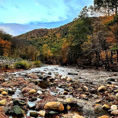
The historical photograph shows exposed boulders, moving river water and autumn-colored hills. It adds forest scenery but does not establish the designated Cold River Pool entrance, a wading route or today's water level. The published 2026 unguarded swimming season ended September 7; autumn colors in a photograph are not authorization to enter any pictured river section. Check the specific seasonal swim area and current DCR notices separately from a woodland outing.
Use DCR's Cold River Road, Charlemont address and camping-area map for the named Cold River Pool. Confirm current access with the forest; no second pool or arbitrary roadside entrance is established.
Use DCR's Cold River Road, Charlemont address and camping-area map for the named Cold River Pool. Confirm current access with the forest; no second pool or arbitrary roadside entrance is established.
Confirm the entrance, parking arrangements, and legal access with the land manager. A map pin does not establish a public right of access. Follow posted routes and never block gates or driveways.
Designated seasonal swimming at Cold River Pool, unguarded in 2026; hiking, camping, fishing and paddling according to forest rules. Cold River Pool's published 2026 swimming season May 23 to September 7, unguarded. General forest day use sunrise to sunset; check the next waterfront schedule and current notices. Public park access does not necessarily include permission to swim. Respect private property and posted restrictions.
Water conditions can change quickly. This listing does not provide a current safety or water-quality assessment. Check official alerts and avoid entering water when conditions or permission are uncertain.
Bring sturdy water shoes to protect your feet on rocks and slippery surfaces. A waterproof dry bag keeps your phone, keys, and valuables safe. Pack a quick-dry towel, sun protection, and drinking water - never drink from the natural water source.
Nearby places from saved public map data, not necessarily facilities at the swimming spot. Confirm access, hours, fees, and amenities with the operator before you drive.
Map data retrieved 2026-06-15
Public parking space
J2RR+FF, Drury, MA 01343
Campground
Cold River Rd, Charlemont, MA 01339
Picnic ground
1359 Mohawk Trail, Charlemont, MA 01339
State park
Cold River Rd, Charlemont, MA 01339
6,000+ acres of woodland for hiking, rivers & streams for fishing, plus cabins & multiple campsites.
Hiking area
Williamstown, MA 01267
State park
68 Wahconah Falls Rd, Dalton, MA 01226
48-acre wooded state park with waterfalls, picnic areas & hiking trails, plus fishing & restrooms.
Campground
2458 Hancock Rd, Williamstown, MA 01267
Park
200 Windsor Lake Rd, North Adams, MA 01247
DCR identifies Cold River Pool at Mohawk Trail State Forest in Charlemont. Use the manager's camping-area map, not an assumed pair of wild river pools.
DCR's 2026 waterfront schedule labels Cold River Pool unguarded. Do not expect a lifeguard when planning your visit.
The published 2026 Cold River Pool season ends September 7. October is outside that swimming-service calendar, though the forest's general day-use hours are sunrise to sunset.
The forest manager lists Cold River Road, Charlemont. Follow the current DCR map and posted routes to Cold River Pool, rather than parking at an arbitrary roadside shoulder.
Yes. The forest advertises 53 campsites and six cabins, with reservations required. Campsites are offered mid-May through mid-October; check availability and separate cabin or group rates.
The forest prohibits alcohol and littering, and pets are prohibited in cabins. General dogs-allowed information is not permission to take a pet into the swimming area; check its posted waterfront rules.
Historical directions are retained separately; use current manager instructions for travel.
The reviewed historical gallery shows rocky river and autumn woodland scenery in the state-forest collection. It does not establish the designated Cold River Pool entrance or current swimming-season availability.
Follow current manager routes and fire restrictions, respect private parcels and pack out waste.
Browse every listed natural swimming spot in Massachusetts.
Find similar dcr inland designated swimming area within a state forest destinations across the directory.
See under-the-radar places and local favorites in the same state.
Compare easier-access destinations and safer planning options.
Use this safety guide before entering any natural water.
Safety & Access Notice
This information is for general planning only and may be incomplete, outdated, or inaccurate. Access rules, closures, water levels, currents, hazards, and legal restrictions can change at any time. Always verify current rules with the land manager or official source before visiting.
You are responsible for your own safety and for following all posted signs, laws, and local regulations. Read the full disclaimer.
53 wooded campsites and six overnight cabins advertised. Campsites available mid-May through mid-October with reservations required. Pets prohibited in cabins.
Loading weather data…
Safety & Access Notice
This information is for general planning only and may be incomplete, outdated, or inaccurate. Access rules, closures, water levels, currents, hazards, and legal restrictions can change at any time. Always verify current rules with the land manager or official source before visiting.
You are responsible for your own safety and for following all posted signs, laws, and local regulations. Read the full disclaimer.
Joshua Havens created Hidden Swimming Holes to make it easier for people to find — and safely visit — natural freshwater swimming destinations across the United States. He researches access conditions, water quality resources, and land management rules so you don't have to start from scratch. He holds a strong belief that good outdoor recreation information should be accurate, honest about its limitations, and freely available.
Discover other amazing natural swimming destinations across America