Dawson Forest Wildlife Management Area
Hiking area
4.5 (44)
Dawsonville, GA 30534

Background: generated illustration, not a photograph of this location.
Plan an Edge of the World trail visit near Dawsonville. Check required licenses or Lands Passes, hunting closures, boardwalk access and whitewater cautions.
Status summarizes our reviewed record, not today's opening or safety. Check current rules, swimming boundaries and notices before visiting.
Location
A closer look
Photos show past visits, not current water levels or swimming conditions. Select a photo to view it larger.
This is a desk-researched listing. A record update or map check does not confirm current swimming permission or water conditions.
Found an error? Send a correction with the location and a source. How we research listings.
Edge of the World is a riverside trail and rapids destination west of Dawsonville, within Dawson Forest Wildlife Management Area. The appeal is the view of water moving through exposed rock and forest. It is not a developed swimming pool or a managed natural water slide.
Every visitor age 16 or older needs a valid Georgia license that permits hunting or fishing, or a Georgia Lands Pass, even for a sightseeing visit. Arrange the appropriate credential before arrival; the local visitor bureau says there is no payment kiosk at the trail. Check the DNR property page for current requirements and hunting-related access restrictions.
The visitor bureau places the riverside turnout on the north side of Highway 53 at the Amicalola crossing. It describes a half-mile one-way boardwalk route and accessible viewing platforms. Those features do not establish step-free access to a swimming entry or accessibility of the entire riverside route. Follow signed parking and trail access rather than this listing's former town-level map coordinate. There are no restrooms on site; bring drinking water and carry out your rubbish.
The local visitor bureau notes swimming and tubing along the broader river, but warns that the section below Highway 53 is serious whitewater. We have not verified a designated swimming area or a suitable water-entry point at these rapids. Do not slide down the rocks, jump into pools or assume summer flows are safe. Plan this stop for riverside viewing unless you have activity-specific guidance appropriate to the conditions.
DNR closes trails to non-hunters during firearms deer hunts and before 10 a.m. during archery deer and turkey firearms seasons. Consult current dates and posted notices before travel. Restrictions for the City of Atlanta tract, including its road closures, should not be treated as a blanket closure of the Highway 53 access.
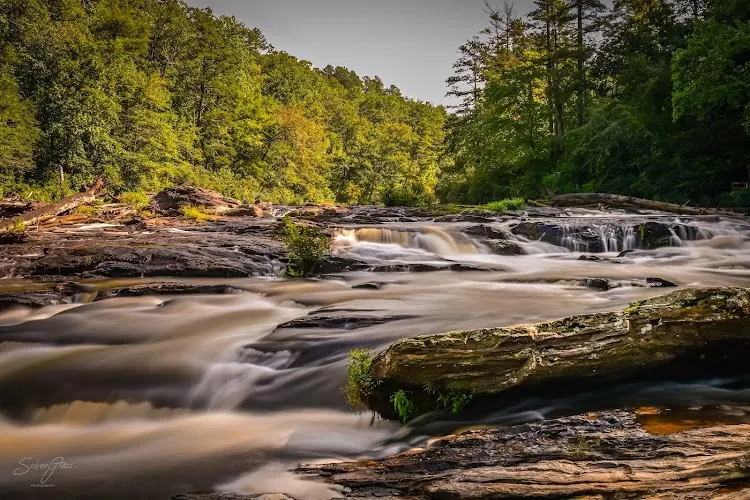
The selected image shows rocky shelves and rapids in the trail's saved collection. Its long-exposure appearance smooths moving water and cannot show present current strength, depth or a safe crossing. The photographer's visible signature is retained. Plan an authorized trail or viewing visit under current rules; the photograph is not bathing permission or a water-entry route.
Use the signed Amicalola River access at the Highway 53 crossing west of Dawsonville. The local visitor bureau describes the turnout on the north side of the highway. Follow posted parking and trail signs. No precise parking or swimming-entry pin has been verified here.
Managed Dawson Forest WMA access. Each visitor age 16+ needs an eligible Georgia hunting/fishing license or Lands Pass. Check hunting-related trail closures; no on-site payment kiosk.
Confirm the entrance, parking arrangements, and legal access with the land manager. A map pin does not establish a public right of access. Follow posted routes and never block gates or driveways.
Current swimming permission has not been independently confirmed for this listing. Check official rules, fees, hours, and closures before visiting. Public park access does not necessarily include permission to swim. Respect private property and posted restrictions.
Water conditions can change quickly. This listing does not provide a current safety or water-quality assessment. Check official alerts and avoid entering water when conditions or permission are uncertain.
Nearby places from saved public map data, not necessarily facilities at the swimming spot. Confirm access, hours, fees, and amenities with the operator before you drive.
Map data retrieved 2026-06-15
Hiking area
Dawsonville, GA 30534
Hiking area
Dawsonville, GA 30534
Park
Dawsonville, GA 30534
Public bathroom
War Hill Park Rd, Dawsonville, GA 30534
Public bathroom
13 S Park St #1220, Dahlonega, GA 30533
Public bathroom
375 Gilmer Ferry Rd, Ball Ground, GA 30107
Visitor center
418 Amicalola Falls Road, Dawsonville, GA 30534
Visitor center
418 Amicalola Fls Ldg Dr, Dawsonville, GA 30534
Woodland adventure lodge offering organized activities, plus a restaurant, a zipline & a fire pit.
Yes. Visitors age 16+ need a valid Georgia license permitting hunting or fishing, or a Lands Pass. The requirement also applies to non-hunting visits.
The visitor bureau says there is no on-site payment kiosk. Arrange the appropriate license or pass before arrival.
Do not treat the rapids as a recreational slide. The visitor bureau warns of serious whitewater below Highway 53, and a suitable swimming entry has not been verified here.
No. DNR lists full-day closures during firearms deer hunts and closures before 10 a.m. during archery deer and turkey firearms seasons. Check current dates and posted notices.
Stay clear of powerful currents and slippery rock edges; do not slide or jump into the rapids; supervise children closely; check hunting closures before walking; do not assume lifeguards or a designated swimming zone.
Photograph the rapids from permitted trail viewpoints without entering the water or climbing wet rocks.
Follow Leave No Trace principles. Avoid littering, respect wildlife, and stick to designated trails to preserve the ecosystem.
Browse every listed natural swimming spot in Georgia.
Find similar river destinations across the directory.
See under-the-radar places and local favorites in the same state.
Compare easier-access destinations and safer planning options.
Use this safety guide before entering any natural water.
Safety & Access Notice
This information is for general planning only and may be incomplete, outdated, or inaccurate. Access rules, closures, water levels, currents, hazards, and legal restrictions can change at any time. Always verify current rules with the land manager or official source before visiting.
You are responsible for your own safety and for following all posted signs, laws, and local regulations. Read the full disclaimer.
Do not assume camping at this access. WMA camping is restricted to designated locations and applicable dates.
Loading weather data…
Safety & Access Notice
This information is for general planning only and may be incomplete, outdated, or inaccurate. Access rules, closures, water levels, currents, hazards, and legal restrictions can change at any time. Always verify current rules with the land manager or official source before visiting.
You are responsible for your own safety and for following all posted signs, laws, and local regulations. Read the full disclaimer.
Joshua Havens created Hidden Swimming Holes to make it easier for people to find — and safely visit — natural freshwater swimming destinations across the United States. He researches access conditions, water quality resources, and land management rules so you don't have to start from scratch. He holds a strong belief that good outdoor recreation information should be accurate, honest about its limitations, and freely available.
Discover other amazing natural swimming destinations across America